Jadual Kandungan
Hutan Bukit Dinding
Dirujuk oleh
Bukit Dinding ialah bukit berhutan setinggi 291m (menurut Google Earth 2022: 302m) di Kuala Lumpur, terletak di antara Setiawangsa dan Wangsa Maju. Nama “Dinding” merujuk kepada lerengnya yang curam, dengan kecerunan yang lazimnya melebihi 45 darjah, sekaligus menjadi “dinding” yang memisahkan Wangsa Maju dan Setiawangsa. Bagi penduduk setempat, ianya dianggap kawasan hijau terakhir di situ. Lokasinya berdekatan dengan Highland Tower (di sebelah timurnya, yang telah runtuh pada 11 Disember 1993) dan Bukit Antarabangsa, yang merupakan sebahagian daripada Banjaran Titiwangsa: “Bukit Dinding is a forested hill with published height of 291m[1] in Kuala Lumpur sitting in between Setiawangsa and Wangsa Maju. The true height of Bukit Dinding is 302m[2] as recorded by Google Earth in year 2022. “Bukit Dinding[3]” in Malay language means “The Wall Hill” - very much referring to its steep, extreme gradients often over 45 degrees. At current, the hill also behaves as the “wall” separating 2 suburbs of Wangsa Maju and Setiawangsa. For the locals, this hill is often described as the last remaining green lung between these highly dense suburbs. The hill has close proximity to Highland Tower and Bukit Antarabangsa, which are parts of the main Titiwangsa Range – infamous for their beauty as well as their notorious landslides.”
Hutan ini terdiri daripada tumbuhan primer dan sekunder. Sebelum ini ia merupakan sebahagian daripada ladang getah Hawthornden. Terdapat banyak pokok getah tua, acacia, sukun, terap, pulai, dan lain-lain. “Black Bat Flower” dikatakan tumbuhan asli di situ. Beberapa spesis hidupan liar juga boleh ditemui:“The forest consists of both Primary and Secondary vegetation. Being previously part of the Hawthornden Rubber Estate, there are many old rubber trees and its saplings, Acacia, Atrocarpus species (Sukun and Terap), Leucaena species and Alstonia augustifolia (Pulai). The Primary vegetation has yet to be studied and revealed. The Black Bat Flower is indigenous in Bukit Dinding. It is a species known to be very rare in the wild and it cannot be cultivated easily because it can survive only under specific environmental conditions. Black bat flower is listed as endangered plant in many countries. As for animals, there are many species of snakes, lizards, civet cats, monkeys and wild boars. Smaller faunas are many - hikers ongoingly upload photos of exotic insects, worms and invertebrates on social medias- but these are yet to be scientifically identified. A number of interesting photos could be found on the Facebook page of “Friends of Bukit Dinding”.”
(Sumber: Wikipedia: Bukit Dinding).
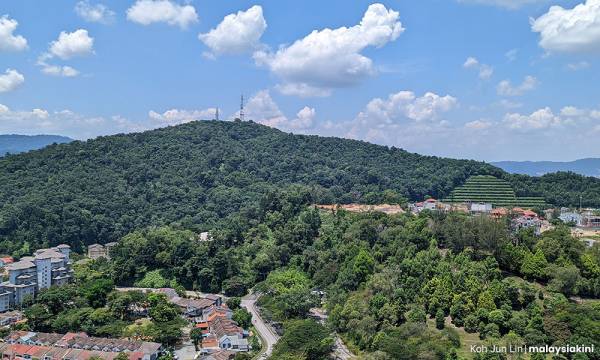
Bukit Dinding (Koh Jun Lin @ Malaysiakini, 25-28 September, 2022: |"Penduduk bantah kelulusan pembangunan DBKL di bukit 'berisiko runtuh'").
Kronologi Sejarah
1870: Antara Lokasi Perang Klang (1867-1874)
Kawasan sekitar Bukit Dinding, termasuk Ulu Gonggang (kemudiannya Ladang Gonggang dan Hawthornden) di sebelah barat, dan lembah Sungai Gisir di sebelah utara, menjadi antara lokasi Perang Klang (1867-1874).
LATAR PERISTIWA: Gonggang / Setapak (1800-an)
Pertempuran di pinggir Bukit Dinding
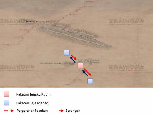
Pada tahun 1870, kawasan sekitar Bukit Dinding pernah menjadi salah satu lokasi pertempuran dalam siri Perang Kelang / Perang Saudara Selangor di antara kumpulan Tengku Kudin dan Yap Ah Loy (Raja Abdullah) dengan kumpulan Syed Mashhor dan Chong Chong (menyebelahi Raja Mahadi). Di dalam salah satu babak pertempuran tersebut, pasukan Syed Mashhor telah menyerang pasukan Yap Ah Loy (diketuai Hiu Fatt and Tung Khoon) di Ulu Klang dari Ampang, manakala pasukan Chong Chong mara dari sebelah barat Bukit Dinding (yang kemudiannya menjadi Ladang Gonggang dan Hawthornden), lalu mengepung pihak lawan dari belakang, kemungkinan dari lembah Sungai Gisir di sebelah utara Bukit Dinding. Namun pasukan Yap Ah Loy yang lain (diketuai Chung Piang) sempat sampai ke lokasi kepungan dan setelah pertempuran yang panjang, berjaya mematahkan serangan lalu memaksa pasukan Chong Chong berundur kembali ke Ampang:-
“Ketika aku sedang menelaah tentang sejarah Perang Saudara Selangor atau lebih dikenali sebagai Perang Kelang, aku telah terbaca satu artikel sejarah yang menarik yang berkaitan dengan lokasi di Wangsa Maju iaitu Bukit Dinding. Tulisan artikel ini memaparkan kisah siri perang Kelang yang berlaku pada 1870 dan lebih dikenali sebagai The Battle of Ampang. Tulisan artikel ini agak menarik berikutan ia melibatkan sedikit kawasan Wangsa Maju iaitu di sekitar kawasan Bukit Dinding dan kawasan Lembah Sungai Gisir, Hulu Kelang.”
…..
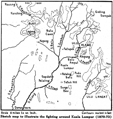
Kiri: Peta sekitar Kuala Lumpur, 1870-1873 (S. M. Middlebrook, J. M. Gullick and C. A. GIBSON-HILL @ Journal of the Malayan Branch of the Royal Asiatic Society, Vol. 24, No. 2 (155), July 1951: |"Yap Ah Loy (1837-1885)", m.s.54).
Kanan: Peta sekitar Bukit Dinding, tahun 1883 (Budak Wangsa Maju, 21 April 2018: |"Sejarah Wangsa Maju: The Battle of Bukit Dinding, The Forgotten War of Perang Kelang").
“In the meantime, Hiu Fatt and Tung Khoon had returned to their improvised camp at Ulu Klang. During the night, much to the surprised of Hiu Fatt and his men, they were woken up by sounds of firearms and shouting, and discovered that Mashhor’s force were in front of their position. Without hesitation, Hiu Fatt immediately gave orders for a direct attack to be made on the enemy. While the fighting was in progress, Chong Chong’s army emerged from the rear of Hiu Fatt's position (presumably along the north flank of Bukit Dinding and down the valley of the Sungei Gisir), thus Hiu Fatt and his men were trapped between two larger units of enemy forces.'” (Kongsi NetWorks, 2000: |"The History of Yap Ah Loy, Kapitan Cina of Kuala Lumpur and Klang (1867-1885)", m.s.24).
“Syed Mashoor telah meminta bantuan daripada Pasukan Chong Chong untuk menyerang Pasukan Yap Ah Loy yang kini telah berkubu di Ulu Kelang. Seramai 600 orang askar Pasukan Chong Chong telah dihantar untuk tujuan tersebut dan mereka berkubu di kawasan Lembah Sungai Gisir di Utara Bukit Dinding. Pada waktu malam tanpa disedari oleh Hiu Fatt and Tung Khoon, Pasukan Syed Mashoor telah menyerang mereka secara serang hendap manakala Pasukan Chong Chong pula menyerang mereka dari arah belakang. Keadaan ini menyebabkan Pasukan Yap Ah Loy terkepung dari arah depan dan belakang.” : “Mashhor himself made his way to Chong Chongas camp near Batu Ampat, and suggested an immediate counter-attack, before Ah Loy's men could consolidate their position. Chong Chong agreed with the proposal and Jhat night led a force estimated at about 1,000 men towards Ulu Klang. Mashhor is said to have- followed him with an equal force, but advancing by a different route. There is actually only one direct line of approach from Ampang to Ulu Klang, that is up the river valley. It seems probable that Mashhor took this course (he had just retreated along it), while Chong Chong made his way round through the present Gonggang and Hawthornden Estates, to the west of Bukit Dinding. In the meantime Hiu Fatt and Tung Khoon had returned to their improvised camp at Ulu Klang. During the night they were woken by sounds of firearms and shouting, and discovered Mashhor's force in front of their position. They immediately gave orders for a direct attack to be made on the enemy. While it was in progress Chong Chong's men came up from the rear, presumably along the north flank of Bukit Dinding and down the valley of the Sungei Gisir. The Capitan China's men were thus trapped between two larger units of the enemy. Fortunately Ah Loy had decided that evening to re-inforce his troups at Ulu Klang, and had sent Chung Piang out to them with 400 men. These arrived in the middle of the conflict, and presumably in the rear of Chong Chong's encircling force. After a long struggle, in which the Capitanas losses amounted to over 40' killed and 100 wounded, Chong Chong was forced to retreat to his stockade at Ampang, “after sustaining a heavy loss”..” (S. M. Middlebrook, J. M. Gullick and C. A. GIBSON-HILL @ Malaysian Branch of the Royal Asiatic Society (MBRAS), July 1951: |"Yap Ah Loy (1837-1885)", m.s. 56).
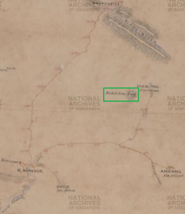
Kiri: Peta Bukit Dinding (dalam petak hijau) dan sekitarnya, berdasarkan peta tahun 1883: “Roads And Tracks Radiating From Kuala Lumpur, And Klang River, Malaya, 1883. Sketch Map shows K. Lumpor (Kuala Lumpur), parts of Klang River, landscape, hilly forests, hill names, hill hachures, roads, tracks, milestones, tin mines at Ulu Klang, Ampang, Pugu and Pataling (Petaling), police stations at Anak Ayer Batu, Kabu Lada and Damansara, tracks, swamps, river and clearings, Klang River, river bank, villages, Ginting Bidei, Klang Gates and others.” (Survey Department, Federated Malay States (F.M.S.) and Straits Settlements (S.S.), 1883 @ National Archives of Singapore: |"Roads And Tracks Radiating From Kuala Lumpur, And Klang River, Malaya").
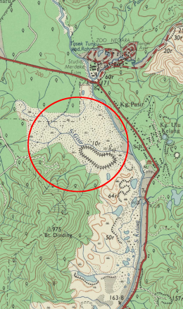
Tengah: Lembah Sungai Gisir, 1967 (Bulatan merah), berdasarkan peta Malaysia : Director of National Mapping, 1967: |"Malaysia, Selangor, Kuala Lumpur, Series: L8010, Sheet 94k, 1967, 1:25 000").
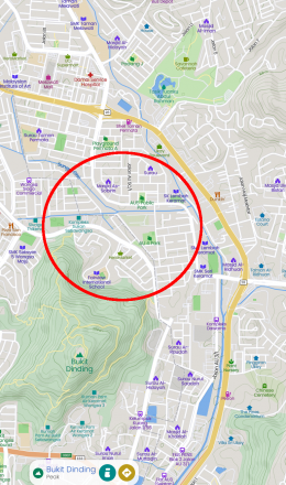
Kanan: Lembah Sungai Gisir, kini (Bulatan merah), berdasarkan peta Mapcarta.
Yap Ah Loy kemudiannya meminta bantuan Raja Asal dari Damansara untuk membantu pasukannya menyerang kubu Raja Mashhor (diketuai Chong Chong dan Che Soho) di Ampang. Raja Asal bersetuju, dan beliau bersama pasukannya bertindak mengepung kubu tersebut: Hiu Fatt dan Tung Khoon dari barat (Kuala Lumpur), Sutan Puasa dari timur laut (Ulu Klang), dan Teng Sam dari tenggara (Ulu Langat). Setelah sebulan dalam kepungan, pasukan Chong Chong dan Che Soho bertindak merempuh kepungan di Bukit Gonggang (kemudiannya selatan Ladang Gonggang) di sebelah barat. Setelah pertempuran yang sengit dan melibatkan banyak korban di kedua belah pihak, akhirnya mereka berjaya melarikan diri ke arah Batu Caves: “The forces were well disposed, but they left two outlets uncovered.. Hiu Fatt and Tung Khoon were attacking from the west, along the line of the present road from Kuala Lumpur to Ampang. Asal and Sutan Puasa to the north-east prevented a retreat to Ulu Klang, while the small force under Teng Sam covered the way over to Ulu Langat. Two courses still lay open to Chong Chong if he could not hold his position. One was to withdraw south over soft ground towards Pudu Ulu, and thence down to Kuala Langat. The other was to strike north-west over the spur of the diminutive Bukit Gonggang (through the southern fringe of the present Gonggang Estate). ….. The battle began about 10 in the morning: an early start never seems to have been popular. By the late afternoon Chong Chong's forces “were routed with the loss of five hundred men…. having not been able to defend both directions. Those who were wounded were numerous. By nightfall Chong Chong and Che Soho, realising the dangerous position they were in, were compelled to flee in the direction of Batu Caves by way of Gonggang (Setapak). The dead bodies of men and horses lay in piles in the waste, and blood was flowing like streams. Both had the intense hatred for the defeat. …” (Source 3, sheet 3 6).” (S. M. Middlebrook, J. M. Gullick and C. A. GIBSON-HILL @ Malaysian Branch of the Royal Asiatic Society (MBRAS), July 1951: |"Yap Ah Loy (1837-1885)", m.s. 57).
“Sejarah Bukit Dinding ini telah direkodkan seawal 1870 dan telah dipetakan oleh British pada 1883 berikutan terdapat aktiviti pembukaan lombong bijih timah di Ulu Kelang oleh Raja Abdullah.
…..
136 tahun selepas pertempuran ini berlangsung, aku telah cuba untuk menjejak kesan peperangan ini. Tidak banyak cerita yang diketahui berkenaan pertempuran Bukit Dinding ini (The Battle of Bukit Dinding) di dalam internet dan juga buku sejarah melainkan daripada rekod sejarah Yap Ah Loy. Namun begitu, peristiwa The Battle of Bukit Dinding ini seharusnya direkodkan sebagai satu sejarah Wangsa Maju dan menunjukkan bahawa Bukit Dinding di Wangsa Maju ini menjadi saksi keterlibatan kawasan ini di dalam peristiwa sejarah Perang Kelang atau Perang Saudara di Selangor.”
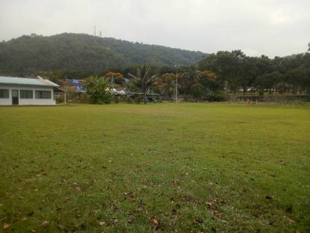
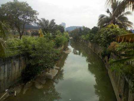
Kiri: “Kawasan Padang di AU4 yang terletak di lembah Sungai Gisir, Hulu Kelang. Adalah dijangka di sinilah berlakunya pertempuran The Battle of Bukit Dinding di antara Pasukan Yap Ah Loy dan Pasukan Chong Chong / Syed Mashoor, Kawasan lapang ini terletak berhampiran dengan Sungai Gisir dan dahulunya terdapat kawasan perkampungan Melayu di sini yang dikenali sebagai Kampung Seri Lembah Keramat. Namun begitu tapak pertempuran sebenar masih tidak diketahui berikutan tiada rekod asal ditemui di dalam rekod sejarah dan kawasan sekitar Bukit Dinding dan Sungai Gisir juga telah dibangunkan dengan pesat.”
Kanan: “Sungai Gisir di Lembah Keramat, Ulu Kelang. Kini telah menjadi longkang besar atau monsoon drain di lokasi. Pada waktu dahulu, Sungai Gisir ini dipenuhi dengan sumber bijih timah dan menarik perhatian Raja Abdullah untuk melombong di sekitar kawasan Sungai Gisir ini. Kesan lombong bijih timah ini telah pun hilang di dalam lipatan sejarah dan kawasan Ulu Kelang kini telah pesat membangun tanpa sedikit pun sebarang kesan sejarah yang ditinggalkan di sini.”
(Sumber: Budak Wangsa Maju, 21 April 2018: |"Sejarah Wangsa Maju: The Battle of Bukit Dinding, The Forgotten War of Perang Kelang").
1883: Kawasan Perlombongan Gonggang
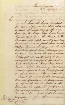
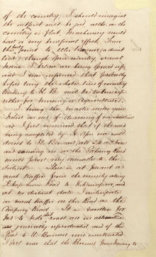
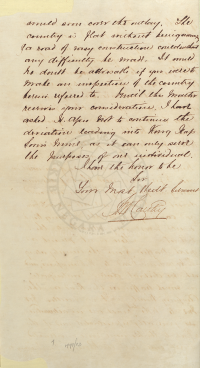
Ketika peringkat awal campurtangan Inggeris pada tahun 1880-an, kawasan lembangan Sungai Bunus yang dikenali sebagai “Gonggang” (kemudiannya Setapak) telah pun menjadi antara pusat perlombongan bijih timah. Ia beransur berkembang sehingga ke hulu Sungai Bunus di sebelah barat laut Bukit Dinding, iaitu di sekitar Wangsa Maju kini. Keadaan ini telah direkodkan di dalam sepucuk surat bertarikh 24 September 1883, daripada juruukur M'Carthy kepada H.F.Bellamy, ketika beliau mencadangkan pembinaan jalan baru bagi menghubungkan kedua-dua lokasi tersebut:-
“I have the honor to report for your information that while on a visit of inspection of the road leading to Kong Yap Soon's mine I heard that from this mine to the Boonoose, the whole country was being opened up and a great deal is(?) working orderly. Chinese towkays who have some time past been turning out good tin ore. Under the circumstances I thought it worth while to proceed along the bridle path for about a mile or so past Kong Yap Soon's mine. After proceeding about 400 yds I came upon a mine lately opened on which many Chinese were working. About 1/2 a mile further on, extensive mining operations are being carried on & from the number of sheds ? this place has the appearance of a promising village. I noticed several hundred Chinese at work here & busily engaged. From the general appearance of the country, I should imagine the output will be good, altho, as the country is flat, machinery would have a very beneficial effect. From this last point to Ulu Boonoose (a direct line) through open country, several mines I believe are being opened up, and I was informed that probably before long the whole line of country leading to U. B. will be taken up either for mining or agriculture. I bring this matter under your notice as one of deserving of consideration as I feel convinced that if the road being completed by Sr. Akes(?) was contd. direct to U. Boonoose (abt. 2 1/2 or 3 miles) and coming in on the Pahang Road would prove very valuable to this district. There is at present a great traffic from the vicinity along K Yap Soon's Road to K. Lumpur, and at no distant date I anticipate as much traffic on this road as the Ampang Road. It is needless for me to note that roads are in all countries generally reproductive, and if this road to U. Boonoose were constructed I feel sure that the revenue from mining would soon cover the outlay. The country is flat without being swampy & a road of easy construction could without any difficulty be made. It should no doubt be advisable if you were to make an inspection of the country herein referred to. Until this matter receives your consideration, I have asked Sr. Akes(?) not to continue the deviation leading into Kong Yap Soon's mine, as it can only serve the purposes of one individual.”
(Sumber: PEJABAT SETIAUSAHA KERAJAAN NEGERI SELANGOR, 24/09/1883: |"CONSTRUCTION OF GONGGANG ROAD TO ULU BUNOSE").
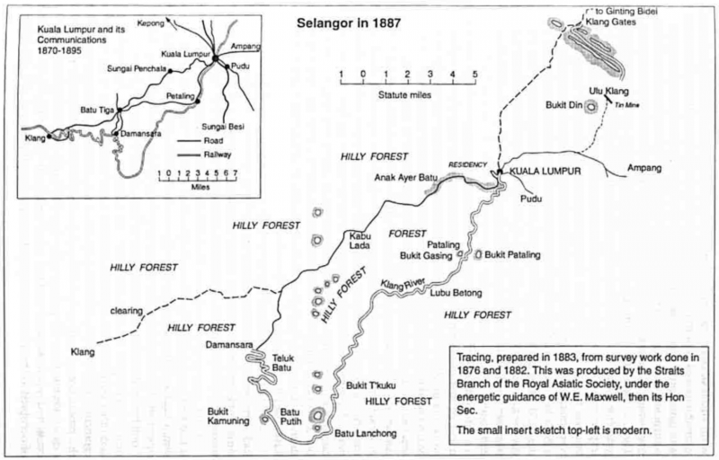
Peta Lembah Klang sekitar 1883-1887. Kelihatan Bukit Dinding di sebelah timur laut berhampiran Klang Gates, ditandakan sebagai “Bukit Din” (J.M. Gullick, 1998: "A History of Selangor 1766-1939", m.s. 85).
LATAR PERISTIWA: Gonggang / Setapak (1800-an)
1888-10: Pembukaan Ladang Hawthornden
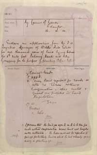
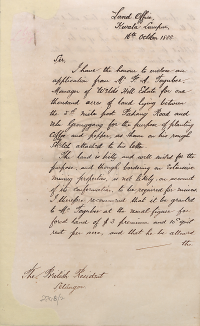
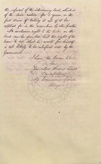
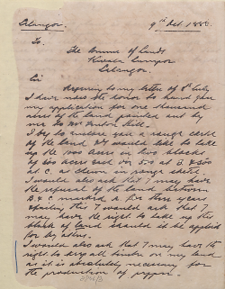
Pada Oktober 1888, Ladang “Ulu Gonggang” di Batu 5 Jalan Pahang Kuala Lumpur (di penghujung sebelah utara pusat perlombongan Gonggang) telah dibuka oleh J. A. Toynbee, bekas pengurus ladang Weld's Hill kepunyaan syarikat Messrs. Hill and Rathborne: “I have the honour to enclose an application from Mr. J. A. Toynbee, Manager of Weld's Hill Estate for one thousand acres of land lying between the 5th mile post Pahang Road and Ulu G®onggang for the purpose of planting coffee and pepper, as shown on his rough sketch attached to his letter. The land is hilly and well suited for the purpose, and though bordering on extensive mining properties, is not likely, on account of its conformation, to be required for mines. I therefore recommend that it be granted to Mr. Toynbee at the usual figure for forest land of $3 premium and 10c quit rent per acre, and that he be allowed the refusal of the intervening land, which is of the same nature, for 3 years, or the first choice of taking it up if it be applied for in the meantime by other parties. No exclusive right to the timber on the land can be granted, but the right of the lessee to cut what he wants for himself is not likely to be interfered with by the Government.” (Henry Conway Belfield @ PEJABAT SETIAUSAHA KERAJAAN NEGERI SELANGOR, 09/10/1888: |"ENCLOSES AN APPLICATIONS FROM MR.F.A.TOYNBEE MANAGER OF WELDS HILLS ESTATE FOR ONE THOUSAND ACRES OF LAND LYING BETWEEN THE 5TH MILE POST PAHANG ROAD AND ULU GONGGANG FOR THE PURPOSE OF PLANTING COFFEE & PEPPER").
Kemungkinan ladang Ulu Gonggang ini berkembang ke Batu 6 Jalan Pahang, dan dinamakan sebagai Ladang Hawthornden. Ladang ini kemudiannya berkembang ke timur/tenggara sehingga merangkumi sebahagian besar kawasan Bukit Dinding: “The opening of the Hawthornden Estate on the Pahang Road (6th mile) has given an impetus to planting enterprise in this direction. A second private planting company has taken up a thousand acres in this direction and commenced work already. Mr. Toynbee, late manager for Messrs. Hill and Rathborne, has done a great deal towards proving the success of planting enterprise in this state and it is to be hoped that the private enterprise on which he is now embarking will bring him the success he deserves.” (The Singapore Free Press and Mercantile Advertiser (Weekly), 5 July 1889, Page 15: |"SELANGOR NEWS").
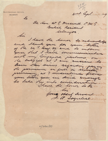
“To: The Hon. W. E. (William Edward) Maxwell. ? British Resident, Selangor. Sir, I have the honor to acknowledge and thank you for your letter of the 24th August 89 and to inform you that I have communicated with my Singapore partners on the subject as I am anxious to learn their views regarding paying the premium in full or remitting(?) premium, as I understand from your letter you are kind enough to take this into consideration. I have the honor to be, Sir, Your obedient servant, J. A. Toynbee.” (PEJABAT SETIAUSAHA KERAJAAN NEGERI SELANGOR, 02/09/1889: |"ACKNOWLEDGES LETTER OF 24TH AUGUST '89 RE REMISSION OF PREMIUMS ON CONCESSIONS").
MAKLUMAT TERPERINCI: Hawthornden Estate (1888-1983)
1890-1892: Kerja Ukur
Kerja-kerja ukur telah dijalankan di Ladang Hawthornden (bersama Ladang Lincoln dan Aberscross di kawasan yang sama) mulai tahun 1890, untuk tujuan pemetaan dan pengeluaran geran bagi ladang-ladang tersebut. Ianya hanya dapat diselesaikan pada tahun 1892, oleh kerana terdapat kawasan hutan tebal di sebelah timur (kemungkinan menghala ke Bukit Dinding) yang dikatakan punca kelewatan:-
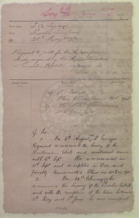
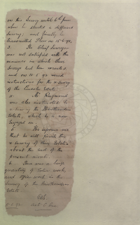
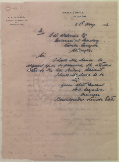
“On 6th August 1890 Mr. Surveyor Raymond commenced the survey of the Hawthornden Estate and continued same until 16th Sept. He recommenced on 21st Sept. and completed in Dec. and finally transmitted plan on 30 Dec. 90. … The Chief Surveyor was not satisfied with the manner in which these surveys had been executed, and on 12.5.92 issued instructions for the re-survey of the Lincoln Estate … Mr. Raymond was also instructed to re-survey the Hawthornden Estate, which he is now engaged on. He informs me that he will finish the re-survey of the estates about the end of the present month. There was a large quantity of extra work, and office work in the survey of the Hawthornden Estate. - 11.6.92” (PEJABAT SETIAUSAHA KERAJAAN NEGERI SELANGOR, 28/05/1892: |"REQUEST TO CALL FOR THE CORRESPONDENCE REGARDING THE HAWTHORNDEN & LINCOLN ESTATES SAVING").
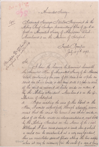
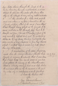
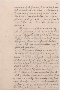
“Amended Survey: Licensed Surveyor J. Walter Raymond to the Acting Chief Surveyor transmitting plan of and report on Amended Survey of Aberscross Estate - Numbered 3 in the Mukim of Setapak. Kuala Lumpur, July 27th 1892. … Although I have now surveyed a route along which a road can be constructed at a very easy gradient there are nevertheless several places along the line adopted where it may be necessary (in the event of a road being constructed) ten or twelve chains through the jungle to the eastern boundary line were impracticable, and was obliged to abandon this route after losing three days in the attempt to carry out my verbal instructions. I then searched for a better route, and the road now shown on my plan (herewith) is the one I finally adopted. Part of the road I was obliged to cut through heavy jungle at the far side of the course, and also as all the angle pegs had to be brought out from Kwala Lumpur (part of the way carried by bullock cart, and the remaining distance by my survey coolies). I althogether was seven working days occupied in finishing this work which I at first hoped would only take about three days to complete.” (PEJABAT SETIAUSAHA KERAJAAN NEGERI SELANGOR, 16/06/1892: |"REQUESTS THAT ALL DESPATCH BE USED IN COMPLETING THE RESURVEY OF LINCOLN AND HAWTHORNDEN ESTATES.").
1897-1904: Perlombongan di Gonggang
Setakat Januari 1897, kawasan Gonggang masih kawasan perlombongan bijih timah, sebagaimana dalam liputan peralihan pengurusan salah sebuah lombong di situ: “Chye Ah Chung, a Mines Orderly in the time of Mr. Hill, who returned to China some time ago, was succeeded, says the Malay Mail, in office by his brother Ah Fong. Between them the brothers held the post to the end of last year. It has since become known that they had all the time been running a mine at Gonggang. Ah Fong is noe keeping a shop at Gonggang while Ah Chung has made away with the “biji.” To make matters worse there is a sum of about $2,000 owing to coolies as wages, and Ah Chung has gone away.” (Pinang gazette and Straits chronicle, 26 January 1897, Page 2: |"LOCAL AND GENERAL.").
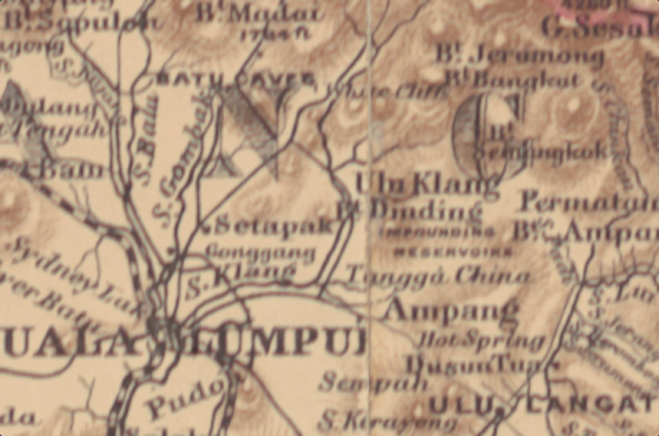
Peta sekitar Bukit Dinding, berdasarkan peta Semenanjung Tanah Melayu tahun 1898. Kelihatan kawasan perlombongan Gonggang ada ditandakan (Edward Stanford @ Royal Asiatic Society of Great Britain and Ireland, Straits Branch, 1898: "A map of the Malay Peninsula / compiled by and published for the Straits Branch of the Royal Asiatic Society, Singapore ; prepared and drawn by John van Cuylenburg, Singapore").
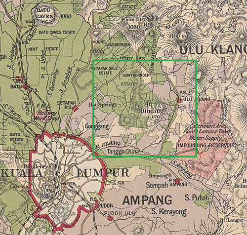
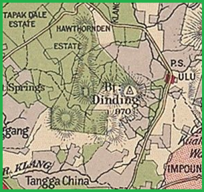
Peta Bukit Dinding (kanan) dan kawasan sekitarnya (kiri), berdasarkan peta negeri Selangor, tahun 1900-an (Edinburgh Geographical Institute, 1904 @ Yale University Library - Digital Collections: |"Selangor, Federated Malay States, 1904 / John Bartholomew & Co ; W.T. Wood, chief draftman").
Di dalam peta tahun 1904 ini, kelihatan kawasan “Gonggang” di sebelah barat daya Bukit Dinding masih menjadi pusat perlombongan bijih timah. Demikian juga di sepanjang lembangan Sungai Klang di sebelah selatan dan timurnya, termasuk anak-anak sungainya (antaranya Sungai Gisir di atas). Turut kelihatan, ladang-ladang kopi yang dibuka secara besar-besaran sejak 1880-an, seperti Batu Caves di sebelah barat laut, dan Ladang Hawthornden di pinggir sebelah utara dan barat Bukit Dinding: “The first coffee estate was opened on Weld's Hill (named after the then Governor) where Liberian coffee was planted by T. Heslop Hill, who was a partner in the well known firm of Hill & Rathborne, Contractors etc. This firm planted the Ginting Bedai and Batu Caves estates with Arabian Coffee, but later abandoned them owing to difficulties, over labour and the distance from Kuala Lumpur. Javanese and Pahang Malays planted their kampongs with Liberian between the race course and “Lincoln” Estate. Messrs Toynbee, Laird, Currie, and Dougal opened “Hawthornden”; L. Dougal “Edinburgh” at Kepong, also “Roslin” and “Lincoln” in the Setapah Valley. Later the Meikle brothers (“Lairds”) opened “Wardieburn”, and the Glassford brothers, who had planted coffee before in South India, “The Mount” E. V. Carey opened “New Amherst”, A. B. Lake and Paget “Kent”, and Murray Campbell “Aberscross” and all were planted with Liberian Coffee. About two thousand acres in all were then under cultivation on these properties, but about four times that amount of land had been taken up for future development.” (Rimba @ C. Grenier, 1922: |"Bygone Selangor; a souvenir").
1929-1962: Perkembangan Perladangan di Ulu Gonggang
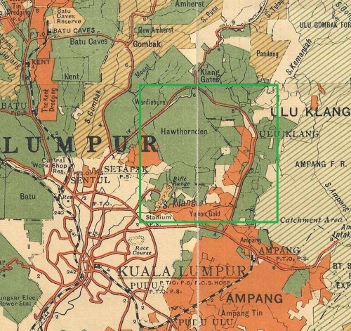
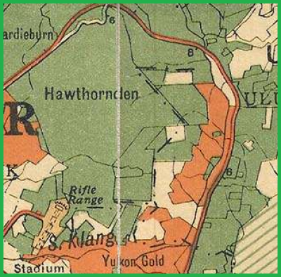
Peta Bukit Dinding (kanan) dan kawasan sekitarnya (kiri), berdasarkan peta negeri Selangor, tahun 1929 (Edward Stanford @ F.M.S. Survey Department, 1929: |"1929 F.M.S. Wall Map of Selangor (Kuala Lumpur)").
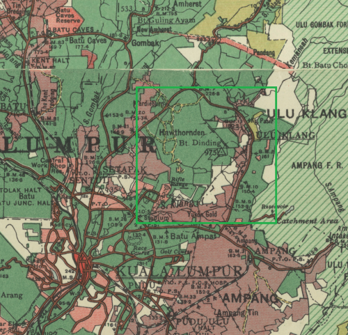
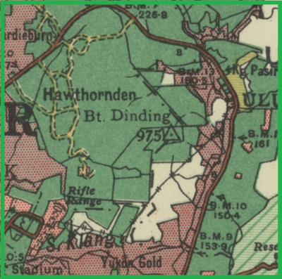
Peta Bukit Dinding (kanan) dan kawasan sekitarnya (kiri), berdasarkan peta negeri Selangor, tahun 1950 (Surveyor General, Malaya, 1950 @ Australian National University: |"Malaysia, Malaya, Selangor 1950, Land Use, South Sheet, 1950, 1:126 720").
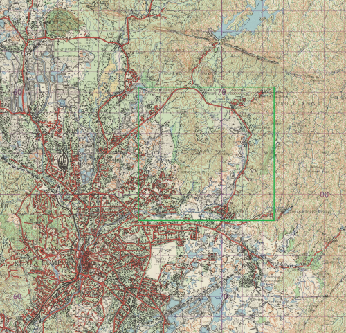
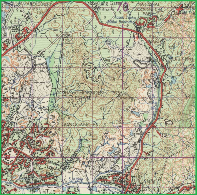
Peta Bukit Dinding (kanan) dan kawasan sekitarnya (kiri), berdasarkan peta Director of National Mapping, Malaysia, 1962: |"Malaysia, Selangor, Kuala Lumpur, Series: L7010, Sheet 94, 1962, 1:63 360").
Menurut Presiden Pertubuhan Suara Setiawangsa, Harun Mohd Amin, sehingga tahun 1960-an terdapat sebuah air terjun di situ, yang kini telah dikambus atau diubah alirannya mengikut binaan sistem perparitan baru: “Sementara itu, Presiden Pertubuhan Suara Setiawangsa, Harun Mohd Amin berkata, rancangan pembangunan di Bukit Dinding perlu dikaji sebaiknya kerana ia bukan sekadar bukit tetapi merupakan kawasan tadahan dan mempunyai laluan air. Harun juga mendakwa berdasarkan sejarah Bukit Dinding, dahulunya terdapat aliran air terjun namun telah ditutup.” (Hidayah Hairom @ Sinar Harian, 20 November 2014 @ Pusat Maklumat Malaysiana, Perpustakaan Negara Malaysia: "Bukit Dinding diancam bahaya").
1965-09-03: Ladang Hawthornden Mulai Dimajukan
Pada 3 September 1965, kerajaan persekutuan telah mengumumkan perancangan sebuah perbandaran baru di Ladang Wardieburn, termasuk sebahagian kecil Ladang Hawthornden. Kemungkinan kawasan tersebut di sekitar Taman Bunga Raya kini. Ini adalah antara pembangunan terawal yang melibatkan Ladang Hawthornden, yang kemudiannya berkembang ke timur/tenggara, ke arah Bukit Dinding: “Ladang Wardeiburn di-Jalan Ulu Klang menjadi sa-buah “Bandar Baru” yang paling moden sa-kali di-Ibukota ini manakala Kerajaan membena kira2 200 penchakar langit 17 tingkat yang mengandongi 42,000 rumah pangsa mulai awal tahun hadapan. … Projek tersebut yang dibahagikan kepada 11 kawasan berasingan akan meliputi seluroh kawasan ladang itu sa-luas 828 ekar termasuk sa-bahagian kechil dari kawasan Ladang Hawthornden.” (Berita Harian, 4 September 1965, Page 5: |"Bandar baru penchakar langit di-Ulu Klang").
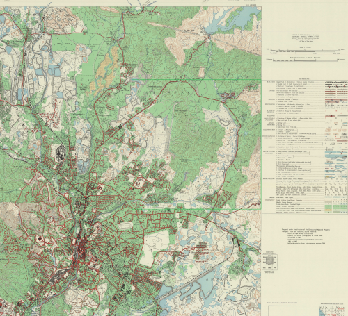
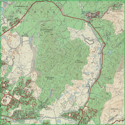
Peta Bukit Dinding (kanan) dan kawasan sekitarnya (kiri), berdasarkan peta Malaysia : Director of National Mapping, 1967: |"Malaysia, Selangor, Kuala Lumpur, Series: L8010, Sheet 94k, 1967, 1:25 000").
1983-12-09: Bandar Baru Ladang Hawthornden
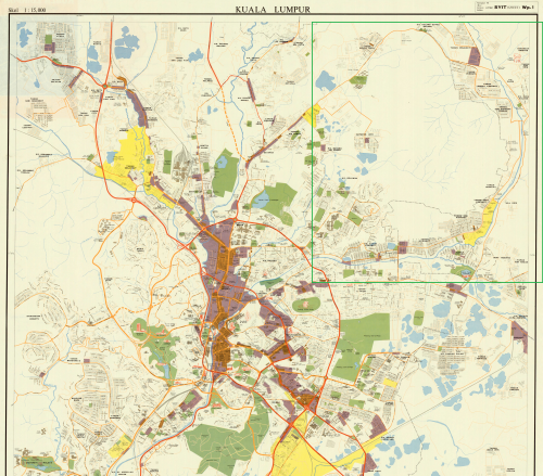
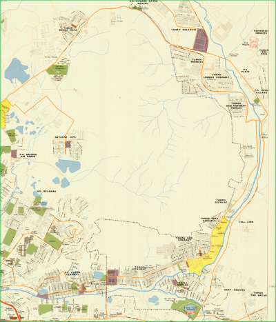
Peta Bukit Dinding (kanan) dan kawasan sekitarnya (kiri), berdasarkan peta Malaysia, Jabatanarah Pemetaan Negara @ American Geographical Society Library, University of Wisconsin-Milwaukee Libraries, 1982: |"Kuala Lumpur / diterbitkan oleh Pengarah Pemetaan Negara". Ketika ini belum ada sebarang pembangunan di Bukit Dinding dan sebahagian besar Ladang Hawthornden di sebelah baratnya.
Pada 9 Disember 1983, Pelan Induk bagi kawasan ini, dikenali sebagai Projek Pusat Pertumbuhan Bandar Baru Ladang Hawthornden, telah diluluskan. Sejak itu, kawasan Wangsa Maju dibangunkan, seksyen demi seksyen, iaitu Seksyen 1 (apartmen kos rendah), Seksyen 2 hingga 4 (apartmen kos sederhana), dan Seksyen 5 (rumah teres, apartmen dan kondominium). Di dalam pelan tersebut, sebahagian daripada Bukit Dinding (ditandakan sebagai “R-12”) telah pun diwartakan sebagai “Tapak Kediaman”, namun tidak dibangunkan, dan masih kekal sebagai kawasan hutan sehingga kini: “Sebelum tahun 1980, keseluruhan kawasan Wangsa Maju merupakan ladang getah yang dikenali sebagai Ladang Hawthornden. Pada tahun 1983, Pelan Induk untuk kawasan ini, dikenali sebagai Projek Pusat Pertumbuhan Bandar Baru Ladang Hawthornden, telah diluluskan, dan ditunjukkan di rajah Figure 3. Tapak Projek ini terletak dalam sector R-12. Gunatanah yang dicadangkan untuk sector R-12 adalah Apartmen Kos Tinggi. Sejak itu, dalam masa 30 tahun sebelum ini, kawasan Wangsa Maju kian dibangunkan, seksyen demi seksyen. Seksyen 1 (apartmen kos rendah), Seksyen 2 hingga 4 (apartmen kos sederhana), dan Seksyen 5 (rumah teres, apartmen dan kondominium) semua telah siap dibangunkan.” (ERINCO Sdn Bhd @ Enviro Knowledge Management Center (EKMC), Jabatan Alam Sekitar, Julai 2017: |"EIA for the Proposed Residential and Commercial Development On Lot 26413 Mukim Setapak and Lot 3538 Mukim Ulu Kelang, Kuala Lumpur For Nova Pesona Sdn Bhd", m.s. 6).
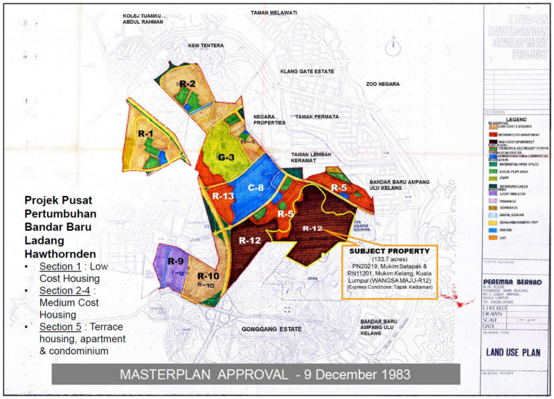
“FIGURE 3: Approved Masterplan for Bandar Baru Ladang Hawthornden” (Peremba Berhad, 9 Disember 1983: Land Use Plan, Kawasan Hawthornden Development Project @ ERINCO Sdn Bhd @ Enviro Knowledge Management Center (EKMC), Jabatan Alam Sekitar, Julai 2017: |"Environment Impact Assessment Report: Proposed Residential and Commercial Development On Lot 26413 Mukim Setapak and Lot 3538 Mukim Ulu Kelang, Kuala Lumpur For Nova Pesona Sdn Bhd:").
Bandar Baru Ladang Hawthornden telah dirasmikan oleh Perdana Menteri ketika itu, Tun Mahathir Mohamad, pada 26 Februari 1984. (PERDANA DIGITAL, Pejabat Perdana Menteri: |"PERASMIAN BANDAR BARU DI LADANG HAWTHORNDEN").
“In 1983, four rubber plantations went through compulsory government acquisition under the then-young Prime Minister, Tun Mahathir.[6] The land acquisition was exercised to tackle the urbanization problem of that era – squatters and insufficient housing for migration of people from the rural area to Kuala Lumpur:
* Ladang Hawthornden
* Ladang Gonggang
* Ladang Kent
* Ladang Wardieburn.
All four plantations were then reclassified and rezoned as “residential lands” - these parcels of lands are then sold to developers.
The vast plantation area - then converted to suburbs - was named Wangsa Maju, the shortened version of Titiwangsa Maju.
One of the plantations – Hawthornden Rubber Estate Company, owned by famous Loke Yew[7] – included plots of lands of the BUKIT DINDING we know today. All of the estates were rezoned as residential, including this plots of land on the hill.
The incidents of notorious landslides of Highland Tower (1993) and Bukit Antarabangsa (2008) had halted slope developments throughout the country. Nevertheless, it is remained unknown why the land plots zoning for slopes of Bukit Dinding (and many other hills in the country) was never rezoned until today.”
(Sumber: Wikipedia: Bukit Dinding: "History").
1983-1995: Ladang Gonggang Menjadi Setiawangsa
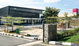
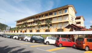
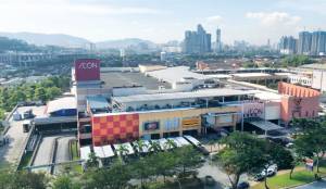
Kiri: Pusat Komuniti Setiawangsa. Tengah: Sekolah Kebangsaan Setiawangsa. Kanan: AEON AU2.
Sepanjang tahun 1983-1995, Ladang Gonggang Estate, termasuk kawasan kaki dan lereng sebelah barat daya Bukit Dinding, mula dibangunkan oleh syarikat Island & Peninsular (I&P) Group Sdn Bhd, kemudiannya dikenali sebagai “Taman Setiawangsa”. Peringkat terakhir pembangunan ini ialah Puncak Setiawangsa, dan disiapkan pada tahun 1995:-
“Nama Gonggang kali terakhir digunakan pada tahun 1980an apabila pihak kerajaan melalui syarikat pemaju I&P mula untuk memajukan kawasan yang dikenali sebagai Gonggang Estate atau Ladang Gonggang. … Kampung-kampung kecil yang berada di Ladang Gonggang ini dipindahkah ke Perumahan Kos Rendah yang terletak di Keramat dan nama Gonggang Estate telah ditukar kepada Setiawangsa selepas ia dibangunkan. Sejak daripada itu, nama Gonggang ini akhirnya hilang di dalam lipatan sejarah buat selama-lamanya. Nama Kg Gonggang juga kini telah hilang dan diganti dengan Kg Datok Keramat dan tiada lagi nama Gonggang disebut kecuali di dalam Sejarah Kuala Lumpur. Adalah dipercayai nama Jalan Enggang yang terletak di persimpangan Jelatek / Keramat adalah berasal daripada nama Gonggang dan ditukar oleh pemaju atas sebab yang tidak diketahui. Walaupun nama Gonggang ini telah berkubur, namun begitu sejarah nama Gonggang masih terpahat di dalam dokumen lama Kuala Lumpur dan menjadi sebahagian daripada sejarah Wangsa Maju yang menjadi salah satu daripada daerah yang termaju di Bandaraya Kuala Lumpur ini.” (Budak Wangsa Maju, 23 September 2018: |"Gonggang: Nama yang hilang di Setiawangsa").
““Setiawangsa caters mainly for the upper-middle to upper class. The terraced houses there, especially in Puncak Setiawangsa, are priced from RM700,000 to RM1.5 million while the semidees and bungalows cost RM1.5 million to RM2 million and RM3 million to RM7 million respectively,” says LaurelCap Sdn Bhd executive director Stanley Toh. “Thus, only a certain income group can afford the properties there.” The non-landed residential properties in the area fetch about RM400 psf. According to Toh, Taman Setiawangsa was developed by Island & Peninsular (I&P) Group Sdn Bhd. “Taman Setiawangsa was developed by I&P Group. The foothill and mid-hill areas were developed in stages in the 1980s before work started on Puncak Setiawangsa, which was completed in 1995,” he says. The 100ha suburb comprises about 3,092 residential units, a large portion of which are freehold, he adds. According to Metro REC Sdn Bhd managing director Ng Weng Yew, Setiawangsa is also the operational base for multinational corporations such as Texas Instruments Inc and pharmaceutical company Fidin Universal Sdn Bhd. “Setiawangsa is also well known for Bukit Dinding, a hill that houses a 200-acre forest,” says Ng. … “Setiawangsa comprises foothill and mid-hill areas such as Taman Setiawangsa, Puncak Setiawangsa and Bukit Setiawangsa,” says Ainnura Aerina Sabirin, who grew up in the area.” (Hannah Rafee @ The Edge Malaysia, January 31, 2019: |"Cover Story: Still a popular address for property buyers").
Perihal syarikat Island & Peninsular (I&P) Group Sdn Bhd:-
- 1981-09-21: Island and Peninsular, pemaju di Pulau Pinang, mengambil alih Associated Malaysian Enterprise (AME) @ Visan Holdings, pemilik Gonggang Estate: “Island and Peninsular, which has so far concentrated its property development activities in Penang, is expanding into Kuala Lumpur. In an announcement yesterday, the group said it is acquiring a land owning company, Associated Malaysian Enterprise Sendirian Berhad (AME), from Visan Holding Sendirian Berhad for $35.5 million in cash less the liabilities of AME as at he completion date. … AME's principal asset is Gonggang Estate - a freehold property of about 253 acres located within the Bandar Baru Ampang-Ulu Klang area. Adjoining its north and north eastern border is Hawthornden Estate which has been acquired by the government.” (BUSINESS TIMES, 22 September 1981, Page 13: |"I & P moves into Kuala Lumpur").
- Pengerusinya (setakat |Mei 1982) ialah Tan Sri Datuk Haji Mohd Sany bin Haji Abdul Ghaffar (|Panglima Angkatan Tentera 1977-1981).
- Sekitar Mei 1983, cadangan pelan pembinaan 6,000 unit perumahan, 150 unit kedai, dan sebuah pusat membeli-belah di Ladang Gonggang telah diluluskan, dan bakal dibina mulai akhir tahun 1983: “I & P said the layout plan for the 102-hectare Gonggang Estate site has been approved. The scheme will comprise well over 6,000 residential units, about 150 shophouses as well as a modern shopping and commercial centre. Building work and house sales by progress payments have been planned for the end of this year.” (BUSINESS TIMES, 26 May 1983, Page 12: |"Island & Peninsular to buy third piece of land").
- Projek tersebut dijalankan sekitar tahun 1984: “Besides development activities in Penang, its previous home base, Island & Pen now has three ongoing projects in Kuala Lumpur - a 6,150-unit housing project known as Gonggang Estate in Ulu Klang, a new township in Kinrara Estate and a head office complex in Kuala Lumpur's Golden Triangle.” (The Business Times, 13 November 1984, Page 15: |"Island & Pen in joint venture to develop apartments").
2008-05-15: Deraf Perancangan Bandar Kuala Lumpur 2020 (KLCP 2020)
Akta 267: “Federal Territory (Planning) Act (FTPA)” telah diwujudkan pada tahun 1982 bagi memastikan pembangunan bandar yang lestari. Antaranya ialah menyediakan pelan struktur pembangunan dan mempamerkannya untuk bantahan awam. Sebarang pembangunan yang tidak mengikuti spesifikasi pelan akhir yang diwartakan selepas itu, adalah tidak dibenarkan. Oleh sebab itu, pihak Dewan Bandaraya Kuala Lumpur (DBKL) telah mempamerkan Draf Perancangan Bandar Kuala Lumpur / Draft Kuala Lumpur City Plan 2020 (KLCP 2020), mulai 15 Mei hingga 30 Ogos 2008: “In line with Act 267, DBKL exhibited the plan for public objection from 15th May 2008 to 30th August 2008. This draft plan contained the proposals of DBKL for sustainable development and were the only proposals displayed for public objection in accordance with Act 267. During that period, the public gave their views and submitted for malobjections to various proposals that DBKL was making in the plan and these objections were heard by a Public Hearing Committee (JKPPA). After the objection hearings, amendments and recommendations were made to the Draft KLCP based on the public objections in relation to some proposals that were originally recommended by DBKL. JKPPA officially submitted the Public Hearing Report to the Mayor of Kuala Lumpur on the 20 October 2009. This was the conclusion of the statutory process for public hearings under the Act. No other notice/gazette for any other draft KL Plan or new proposals thereafter was exhibited as required under Section 14 FTPA.”
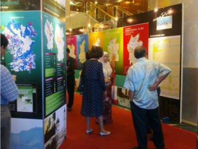
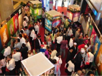
(Sumber: The Center to Combat Corruption and Cronyism (C4), 22 Jun 2020: "Kuala Lumpur City Plan (KLCP) 2020", m.s. 2-8).
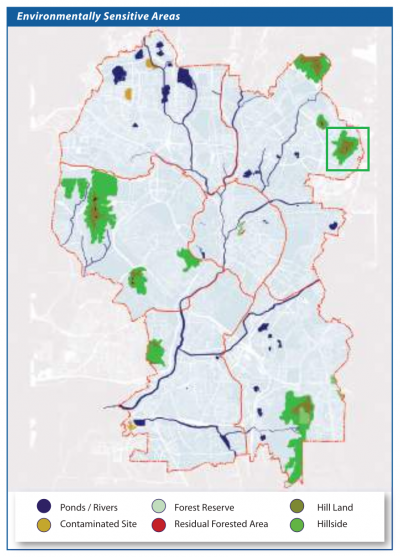

“Strategic Direction 7.2 – Preserving Forest and Wildlife Reserves
Preserving forest and wildlife reserve is important in maintaining habitat for urban wildlife, providing green lung and urban sanctuary for Kuala Lumpur. With only 61 hectares of forest reserve remaining, protection and conservation of forest and wildlife reserve of Kuala Lumpur must be accorded highest priority in the development planning and management of Kuala Lumpur. Apart from its biological importance in providing habitat for urban wildlife, it serves as green lung and urban sanctuary for the community besides improving air quality. These reserves are protected through Land Use Zoning Control and its associated use classes controls where only limited and very low impact eco-tourism are allowed.
SPECIAL PLANNING CONTROL FOR ESA
Control on developments in areas ranked as ESA is through additional planning control
in the KLDCP 2008 which designates an Environmental Protection Zone (EPZ) within the development control plan for Kuala Lumpur.”
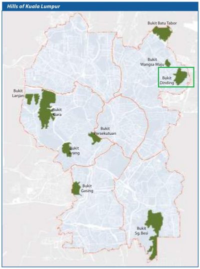
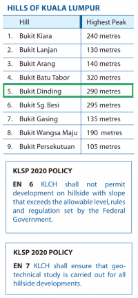
“Strategic Direction 7.3 - Preserving Steep and Hilly Areas
Preserving the hills of Kuala Lumpur that form part of the natural urban landscape of the City for protection against geo-hazards and fulfilling recreational needs of urban dwellers. The hills of Kuala Lumpur are under tremendous threat for development. Recognizing its importance, the hills shall be protected against development via Environmental Protection Zone (EPZ) control. Under such zoning, development and types of activities need to adhere to specific guidelines and requirements. In addition, development can only be approved upon fulfilling requirements imposed by Special Committee on Environmentally Sensitive Areas (Jawatankuasa Penyelarasan Pembangunan Kawasan Sensitif Alam Sekitar Wilayah Persekutuan).”
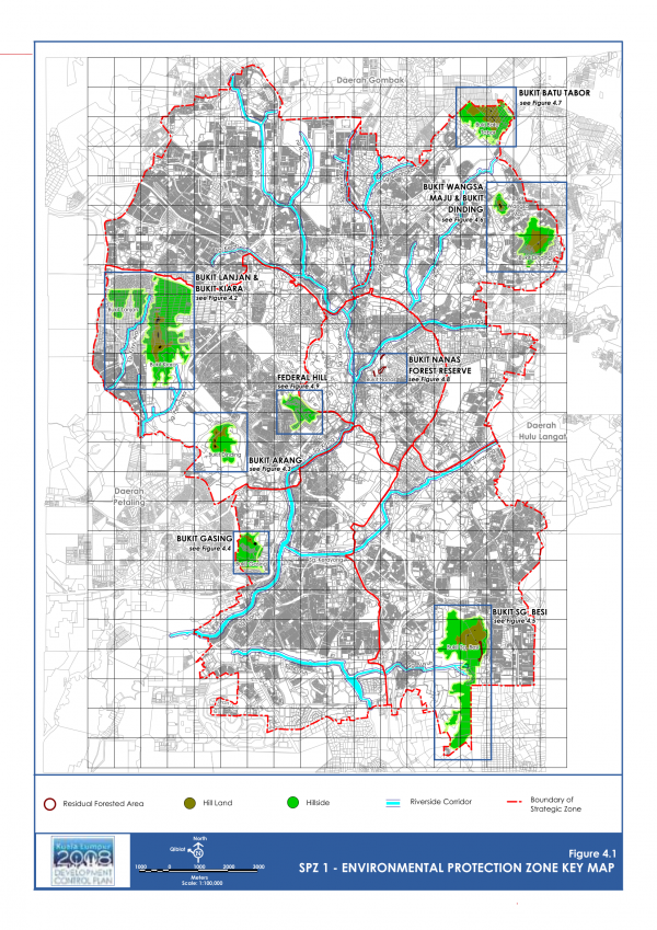
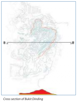
“Environmental Protection Zone (EPZ) refers to an area where additional control and guide with regards to protecting the environment is imposed and specified on development and use of land. The EPZ is an additional layer of development control plan over the zoning control (DCP 1) that needs to be adhered to by any land identified to be within the environmental protection zone. Areas identified as EPZ are highly sensitive to development or changes in land use and needs to be conserved for their limited biodiversity value, to be maintained and enhanced for their life support and recreational function and/or to be protected to mitigate the hazard risks to the surrounding areas. Developments within the EPZ are to be carried out sensitively in accordance to the controls and guidelines specified in this section.”
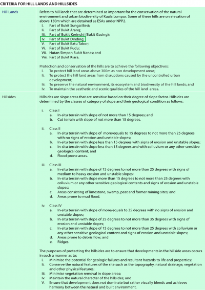
“Hill Land: Refers to areas located between the top of the identified hills in Kuala Lumpur to specified elevation for the respective hills as follows:-
…
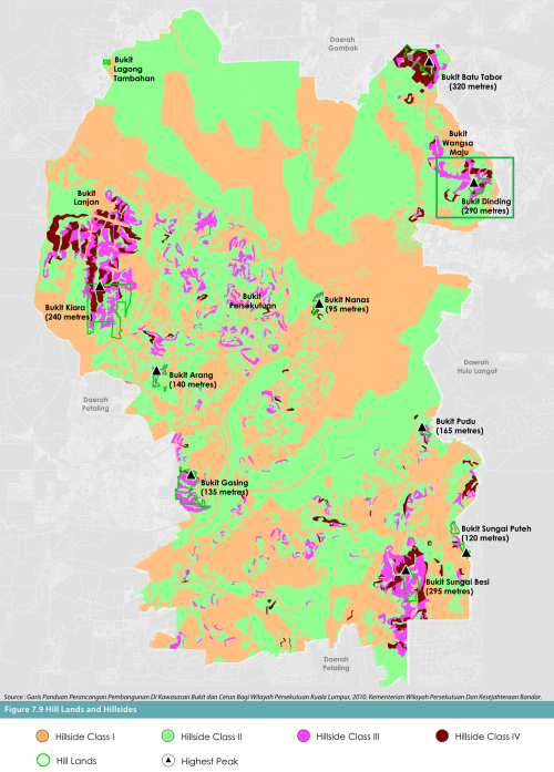
(e) Bukit Dinding: From elevation of 200m to the top of the hill.
…
Protection and conservation of the hills are important for Kuala Lumpur in order to achieve the following objectives:-
i. To protect the hill land area from disruptions cause by the uncontrolled urban development.
ii. To preserve the natural environment, its ecosystem and biodiversity of the hill land.
iii. To maintain the aesthetic and scenic qualities of Kuala Lumpur hill land areas.
Hillside: Refers to areas located within the region specified for the respective hills below:
…
(f ) Bukit Dinding: From foothill to the elevation of 200m
…
The purpose of the hillside areas are to ensure that developments in the hillside areas occurs in such a manner as to:
i. Minimise the potential for geologic failures and resultant hazards to life and property,
ii. Conserve the natural features of the site such as topography, natural drainage, vegetation and other physical features,
iii. Minimise vegetation removal in slope areas,
iv. Maintain the natural character of the hillside,
v. Ensure that development does not dominate, but rather visually blends and achieves harmony between the natural
and built environment.”
Dalam peta cadangan “Environmental Protection Zone” serta “Zoning”, sebahagian besar Bukit Dinding telah pun dirancang untuk pembangunan kediaman (Residential):-
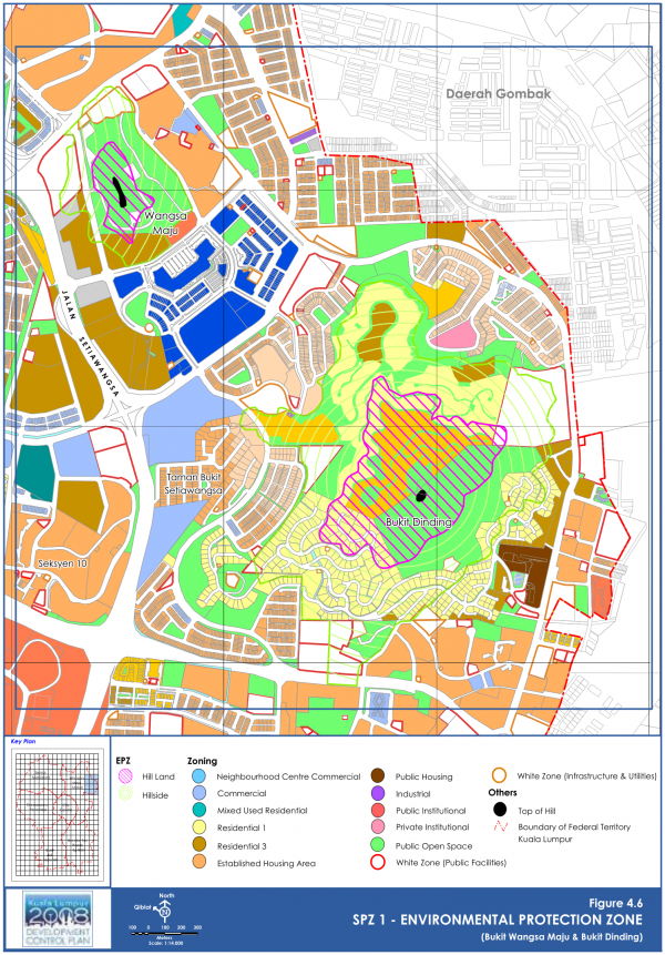
SPZ1 - ENVIRONMENTAL PROTECTION ZONE (Bukit Wangsa Maju & Bukit Dinding).
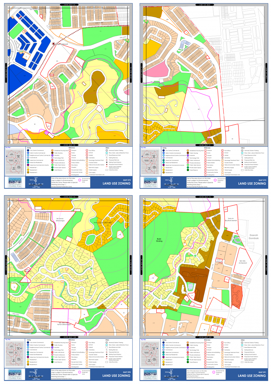
Peta pelan guna tanah sekitar Bukit Dinding.
Sumber: Deraf asal Perancangan Bandar Kuala Lumpur 2020 (Kuala Lumpur City Hall, 2008: |"Draft Kuala Lumpur City Plan 2020", m.s.108-109, 307-309, 314, 581-583, 617-619).
2012-12-28: Tanah Runtuh Puncak Setiawangsa
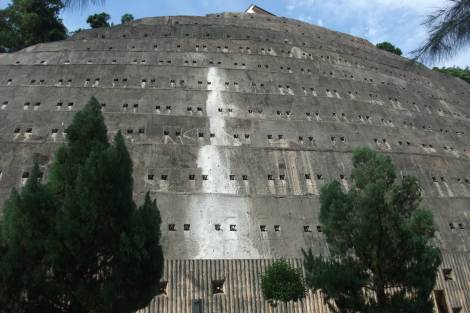
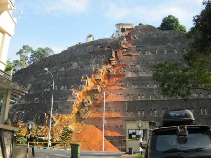
Kiri: Sebelum (Tai Lim @ Blogspot, May 07 2010: |"A Bicycle Ride around Taman Setiawangsa, KL").
Kanan: Selepas (Aida Sue @ DIVA, 31 Disember 2012: |"[ Isu Semasa ] Gambar tanah runtuh di Bukit Setiawangsa ( 7 gambar )").
Pada hari Jumaat, 28 Disember 2012, sekitar 10 malam, kejadian tanah runtuh telah berlaku di Puncak Setiawangsa. Di dalam kejadian itu, sebuah benteng konkrit di lereng bukit setinggi 43 meter (dibina tahun 1992) tidak berupaya menyekat gelongsoran tanah bukit tersebut, lalu sebahagiannya turut merekah dan runtuh. Sebuah rumah di puncak bukit kelihatan rosak teruk, dan sekitar 10 buah rumah terletak berdekatan dengannya. Turut terancam adalah rumah-rumah dan lot kedai yang terletak di kaki puncak tersebut, berhadapan kawasan runtuhan. Sebagai langkah berjaga-jaga, penghuni 46 buah rumah di situ terpaksa dipindahkan: “Penolong Pengerusi Persatuan Penduduk Puncak Setiawangsa, Fauziah Jamaluddin berkata, hanya rumah dan lot kedai berhadapan kawasan runtuhan itu terlibat. “Beberapa rumah lain di kawasan tersebut tidak terjejas, penghuni boleh balik ke rumah masing-masing dan bergerak bebas,” katanya kepada pemberita di tempat kejadian. Fauziah berkata, Dewan Bandaraya Kuala Lumpur (DBKL) akan membina laluan alternatif untuk memudahkan proses keluar masuk penduduk selain mengurangkan kesesakan memandangkan laluan utama perlu ditutup. DBKL turut menyediakan makanan dan pusat komuniti untuk menempatkan penduduk yang terjejas. Bagaimanapun, Jabatan Kerja Raya (JKR) masih memantau situasi tersebut dan membawa masuk jentera berat ke kawasan runtuhan akan menjadi sukar. Pada masa ini, kira-kira 40 anggota Jabatan Bomba dan Penyelamat, Jabatan Pertahanan Awam Malaysia (JPAM), DBKL, Rela dan JKR berada di kawasan terbabit. Menurut pihak berkuasa di kawasan runtuhan, penghuni yang diarahkan berpindah tinggal dengan ahli keluarga mereka yang lain.” (Nicholas Cheng @ Mstar, 29 Disember 2012: |"Penduduk Bukit Setiawangsa Dipindahkan Ekoran Benteng Konkrit Runtuh").
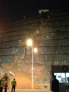
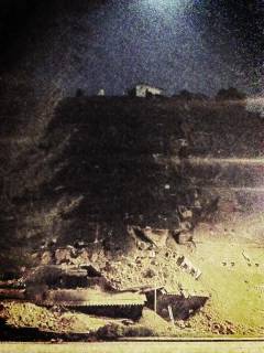
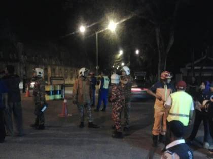
“…gambar di tempat kejadian tanah runtuh berlaku dan gambar gambar merupakan ihsan dari Facebook.”
“Benteng konkrit yang runtuh di Bukit Setiawangsa dikatakan tidak memenuhi garis panduan yang ditetapkan, akui Dewan Bandaraya Kuala Lumpur (DBKL). Datuk Bandar, Datuk Ahmad Phesal Talib berkata, benteng itu dibina pada tahun 1992 tetapi sekiranya pemaju memohon untuk membinanya pada hari ini, maka ia tidak akan diluluskan. Setakat ini tujuh rumah terjejas teruk manakala 57 keluarga lain telah dipindahkan. Beberapa penduduk dipindahkan dan beberapa banglo musnah dan lokasi kejadian tidak jauh dari kediaman Ahli Parlimen Setiawangsa, Datuk Seri Zulhasnan Rafique.” (Aida Sue @ DIVA, 31 Disember 2012: |"[ Isu Semasa ] Gambar tanah runtuh di Bukit Setiawangsa ( 7 gambar )").
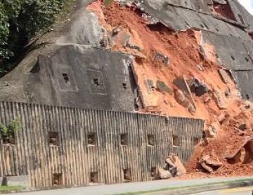
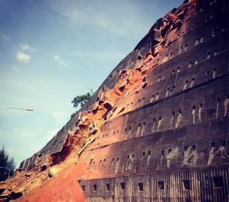
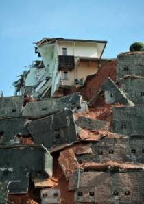
Gambar runtuhan dari pelbagai sudut (Dave Petley @ The Landslide Blog, 29 December 2012: |"A very large engineered slope failure in Malaysia – Bukit Setiawangsa").
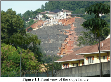
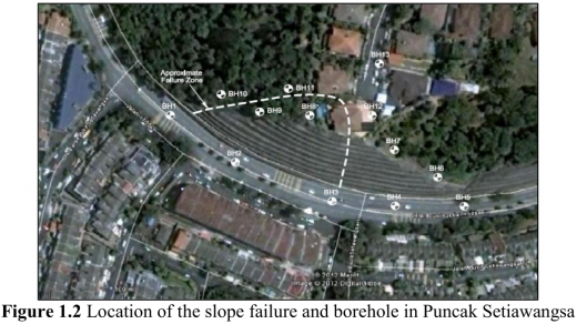
Kiri: “Figure 1.1: Front view of the slope failure”
Kanan: “Figure 1.2: Location of the slope failure and borehole in Puncak Setiawangsa”
“Kegagalan cerun adalah berpunca oleh hujan yang selama 2 hari sebelum berlakunya kegagalan cerun. … Figures 1.1 and 1.2 show the front view of the slope failure and the location of the site. This failure caused a residential house located at the top edge of the slope to partly collapse. The failure also caused one carriageway of the dual carriageway at the bottom of the slope to be closed. The slope contain of 11 berm of cut and steep slope strengthened by permanent ground anchors constructed in the period 1989 - 1991. Each berm has as average height of 5.0m with the horizontal spacing of the anchors was approximately 1.5m.”
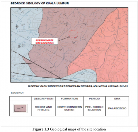
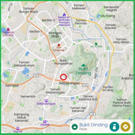
Kiri: “Figure 1.3: Geological maps of the site location”
Kanan: Sekitar lokasi runtuhan kini (Mapcarta).
(Lokasi runtuhan: Bulatan merah)
“A geological map of the site is shown on Figure 1.3. The Map of the Bedrock Geology of Kuala Lumpur, New Series L08010, and Part of Sheet 94K, published by the Geological Survey Malaysia in 1993. The geology indicates that the site is located over the Hawthornden Schist Formation comprising of Schist and Phyllite of the Pre-middle Silurian Period. This formation is made up of metamorphosed rocks unit i.e. moderate to fine-grained quartz-mica-schist, quartz schist and graphitic schist.”
(Sumber: Fatin Hazwani Mohamad Najib, 2016: |"Slope analysis and remedial work on landslide at Taman Setiawangsa, Kuala Lumpur", m.s.12-14).
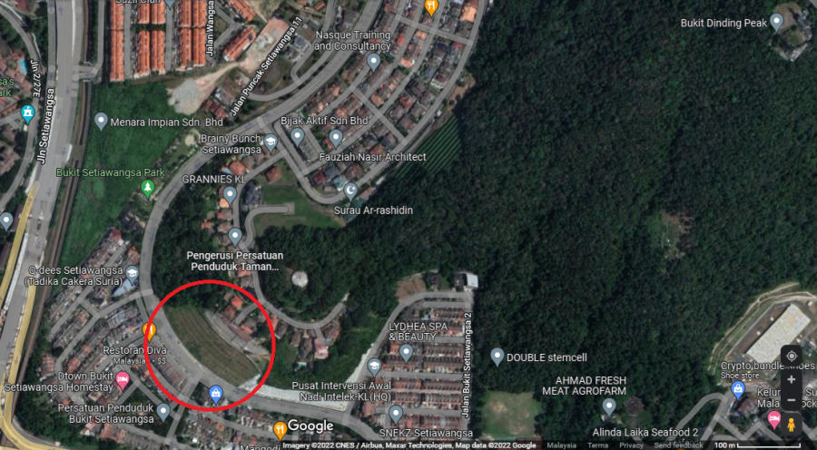
Kawasan benteng konkrit kini (bulatan merah). (Google Maps).
2014-09: Pembangunan di Bukit Dinding
Pembangunan pertama di sebelah timur Bukit Dinding dimulakan oleh Kerjaya Prospek Property Sdn Bhd sekitar September 2014. Walaupun menerima bantahan daripada penduduk setempat, projek tersebut tetap diteruskan dan telah diluncurkan pada 12 Ogos 2017, dan siap sepenuhnya pada tahun 2020. Dikhabarkan, semenjak itu kejadian banjir dan pencerobohan hidupan liar telah meningkat. Antara penduduk yang terkesan ialah rumah pangsa Kelumpuk Serindit, Keramat AU, dan sekitarnya:-
“Rancangan pembangunan tiga projek perumahan mewah, termasuk kondominium di Bukit Dinding Setiawangsa dibimbangi menjejaskan kira-kira 10,000 penduduk sekitarnya termasuk kawasan Setiawangsa, Wangsa Maju dan AU Keramat. Tidak mahu kejadian runtuhan tebing puncak Bukit Setiawangsa (terletak bersebelahan Bukit Dinding) dua tahun lalu berulang, sebanyak 16 persatuan penduduk di sekitar kawasan berkenaan sepakat menubuhkan jawatankuasa bertindak membantah projek berkenaan. Pengerusi Jawatankuasa Bertindak Membantah Pembinaan Kondominium di Bukit Dinding, Zakaria Idris berkata, pihaknya menyedari tentang rancangan pembangunan di situ apabila kerja-kerja salah satu daripada projek berkenaan iaitu pembinaan empat blok kondominium 25 tingkat, telah dimulakan kira-kira dua bulan lalu. Menurutnya, ekoran itu dia terpanggil untuk mendapatkan maklumat jelas berhubung pembangunan di lereng bukit itu namun memeranjatkan apabila dia mendapat tahu ada dua lagi projek yang masih dalam peringkat mendapatkan kelulusan. “Satu-satunya kehijauan di kawasan ini akan musnah dengan pembangunan tersebut. Sekeliling kawasan Bukit Dinding sudah ada pembangunan perumahan dan kedudukannya amat hampir dengan lereng bukit. “Jadi kita bimbang projek atas bukit akan menjejaskan kami yang di bawah ini dengan kejadian banjir lumpur dan tanah runtuh,” katanya kepada Sinar Harian. Katanya, apa yang mereka mahukan adalah projek dihentikan dan Bukit Dinding kekal sebagai kawasan hijau. “Kami akan kumpul petisyen agar projek ini dapat dihentikan. Bukit dan gunung adalah pasak bumi. Kami tidak mahu berlaku bencana apabila ia diteroka,” katanya. Pengerusi Rekreasi AU3, Abdul Razak Omran berkata, penerokaan Bukit Dinding dikhuatiri menambahkan lagi kesan buruk terhadap perumahan sedia ada. Katanya, kini apabila hujan, air akan naik di Jalan 1/56 dengan kesan tanah yang memenuhi longkang, namun akan dibersihkan oleh kontraktor pembersihan bagi melancarkan aliran air. “Kita tak mahu berlaku kes banjir lumpur yang serius dan juga tanah runtuh. Selama ini pun jika hujan lebat dan ribut, banyak berlaku bumbung tercabut bayangkan jika Bukit Dinding sudah ditarah”, katanya.
Wujud air terjun di Bukit Dinding?
Sementara itu, Presiden Pertubuhan Suara Setiawangsa, Harun Mohd Amin berkata, rancangan pembangunan di Bukit Dinding perlu dikaji sebaiknya kerana ia bukan sekadar bukit tetapi merupakan kawasan tadahan dan mempunyai laluan air. Harun juga mendakwa berdasarkan sejarah Bukit Dinding, dahulunya terdapat aliran air terjun namun telah ditutup. “Dalam tahun 60-an ada air terjun di Bukit Dinding jadi ia tidak boleh dibangunkan. Bukannya kita tolak pembangunan, tetapi pembangunan ini akan sengsarakan generasi akan datang,” katanya. Dalam pada itu, Sinar Harian difahamkan jawatankuasa bertindak berkenaan akan mengadakan piket bantahan bersama penduduk dalam masa terdekat bagi menyatakan pendirian mereka terhadap isu berkenaan.
Ahli Parlimen atur pertemuan
Satu pertemuan akan diatur bersama pihak Dewan Bandaraya Kuala Lumpur (DBKL), pemaju projek dan penduduk sekitar bagi mendapatkan penerangan lebih jelas berhubung rancangan pembangunan di Bukit Dinding. Ahli Parlimen Setiawangsa, Datuk Ahmad Fauzi Zahari berkata, pihaknya belum mendapat maklumat lengkap tentang status projek-projek berkenaan termasuk keluasan sebenar tapak pembangunan terlibat. “Disebabkan itu, kita akan atur pertemuan bersama DBKL dan pemaju untuk mendapatkan gambaran lebih jelas,” katanya. ”
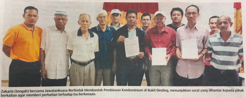
“Zakaria (tengah), bersama Jawatankuasa Bertindak Membantah Pembinaan Kondominium di Bukit Dinding, menunjukkan surat yang dihantar kepada pihak berkaitan agar memberi perhatian terhadap isu berkenaan.”
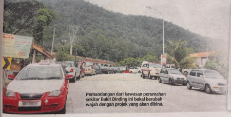
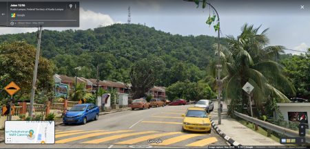
Kiri: “Pemandangan dari kawasan perumahan sekitar Bukit Dinding ini bakal berubah wajah dengan projek yang akan dibina.” (2014)
Kanan: Lokasi yang sama (Jalan 13/56), 2019 (Google Maps: Surau Al Muhajirin, Taman Setiawangsa).
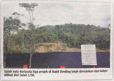
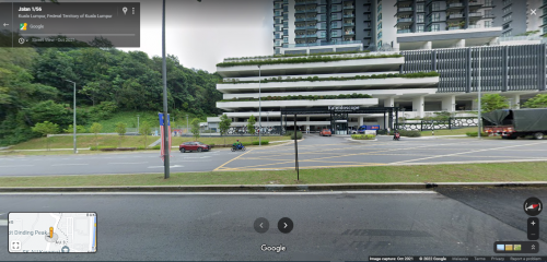
Kiri: “Salah satu daripada tiga projek di Bukit Dinding telah dimulakan dan boleh dilihat dari Jalan 1/56.”
Kanan: Sekitar lokasi yang sama (2021) (Google Maps: Setiawangsa Residency (Kaleidoscope)).
(Sumber: Hidayah Hairom @ Sinar Harian, 20 November 2014 @ Pusat Maklumat Malaysiana, Perpustakaan Negara Malaysia: |"Bukit Dinding diancam bahaya").
Pemaju yang membangunkan kawasan tersebut adalah Kerjaya Prospek Property Sdn Bhd. Projek tersebut tetap diteruskan dan telah diluncurkan pada 12 Ogos 2017, dan siap sepenuhnya pada tahun 2020: “Meanwhile Kerjaya Prospek Property has been busy with a number of projects in the pipeline. On Aug 12, it soft-launched the second phase of Kaleidoscope Condominium, offering 300 units with built-ups ranging between 1,196 sq ft and 1,491 sq ft, with prices starting from RM657,000. The 6-acre leasehold project is located in Setiawangsa, KL and has a total of 600 units.” (Tan Ai Leng @ EdgeProp, 25 Ogos 2017: |"Cemented by decades of love").
“Developer: Kerjaya Prospek Property Sdn Bhd
Direction: East of Bukit Dinding
Affected Residents: Kelumpuk Serindit, Keramat AU and surrounding
Status: Kaleidoscope Condominium - completed in year 2020
Description: In year 2014, the affected residents had actively protested and objected against the development - but to no avail.
Aftermath: Ongoing flooding from rain and bad drainage system. Flood water damaged homes and cars. Wild animals from the hill (especially snakes) escaping into lower homes in affected areas.” (Wikipedia: Bukit Dinding: "List of Developers / Land Owners of Plots on Bukit Dinding").
2017-05-12: Rekahan di Puncak Setiawangsa
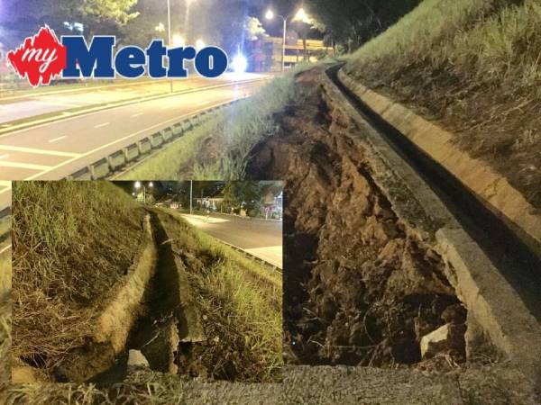
“Rekahan di tebing Jalan 11/55C, Puncak Setiawangsa, Bukit Setiawangsa. FOTO Mazizul Dani”
“Berlaku rekahan di tebing Jalan 11/55C, Puncak Setiawangsa, Bukit Setiawangsa, iaitu lokasi sama berlakunya kejadian tanah runtuh hampir lima tahun lalu. Tinjauan Harian Metro jam 12.30 tengah malam tadi mendapati, rekahan kira-kira lebih setengah meter berlaku di dua bahagian. Gelinciran tanah boleh dilihat di dua bahagian itu iaitu pada zon penampan satu daripada lima zon penampan yang dibina untuk menyokong bukit setinggi lebih 50 meter.”
(Sumber: Mazizul Dani @ Harian Metro, 12 Mei 2017: |"Rekahan membimbangkan").
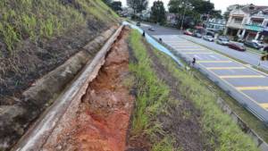
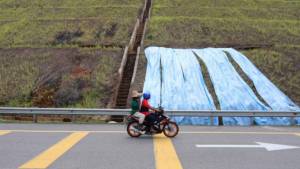
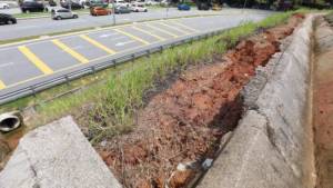
“The cliff along Jalan 11 / 55C, Puncak Setiawangsa, Bukit Setiawangsa appears to have fissures measuring half-a-metre, in this photo taken on, May 12, 2017. — Sunpix by Amirul Syafiq Mohd Din”
“Residents of Setiawangsa near here are having sleepless nights following theappearance of fissures on a slope in the area. “Our biggest nightmare happened in 2012 when a landslide happened at the same area. That incident affected about 700 residents,” Bukit Setiawangsa residents' association president Ahmad Shukri Abdul Shukor told the Sun. He added residents were also unhappy with the way Kuala Lumpur City Hall (DBKL) was handling the issue. Ahmad Shukri said although DBKL had started repair works, it must inform residents adequately about the remedial work. “We realised about the fissures on April 22, so the residents lodged a report with DBKL. “When we did a follow-up, they only informed us that they have received the report but not the action plan. “I think DBKL should inform us on its plans so that we can be prepared,” ahmad Shukri said. Setiawangsa resident Nurul Amira Amiruddin, 21, said she is worried when passing through Jalan 11/55C in Puncak Setiawangsa as the slope near the area is covered with a canvas. She's afraid of a repeat of the incident five years ago which also began with similar earth movement. “This is the only road up, so each time I pass this road, I fear the slope is not safe. “I have no information on why the slope is being covered, but I hope it would not affect he residents' safety,” she said. Checks by the Sun showed that a DBKL contractor had started remedial works in fixing the slope. Attempts to contact DBKL for comments were futile at press time. On Dec 28, 2012, a landslide from the slope caused a luxury bungalow on the hilltop to split into two andforced the evacuation of some 283 residents in the area.”
(Sumber: The Sun Daily, 14 May 2017: |"Setiawangsa residents fear repeat of 2012 landslide").
2017-07: EIA Projek Wangsa Maju
Sekitar Julai 2017, Jabatan Alam Sekitar telah meluluskan Penilaian Kesan Alam Sekitar (Environmental Impact Assessment, EIA) bagi “Projek Wangsa Maju”, yang dicadangkan oleh Nova Pesona Sdn. Bhd., sebuah syarikat yang bakal membangunkan sebahagian kawasan Bukit Dinding yang ditandakan sebagai R-12 dalam Pelan Induk Bandar Baru Ladang Hawthornden 1983. Penilaian ini antara lain telah mengenalpasti kawasan Bukit Dinding sebagai kawasan sensitif. Walaupun kawasan hutan dan taburan hidupan liarnya berstatus “miskin”, antara impak projek yang dinyatakan ialah hidupan liar bakal melarikan diri ke sebelah timur Bukit Dinding, dan memerlukan khidmat pihak Perhilitan bagi memindahkan mereka, contohnya ke Hutan Simpan Ampang di sebelah timur.
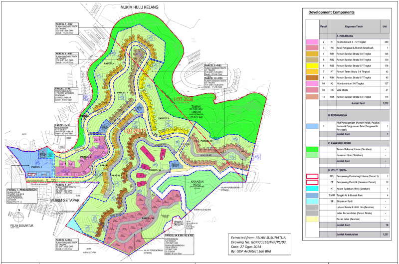
“FIGURE 7: LAYOUT PLAN” (GDP Architect Sdn Bhd, 27 Ogos 2014: PELAN SUSUNATUR, Drawing No. GDPP/1166/WP/PS/03 @ ERINCO Sdn Bhd @ Enviro Knowledge Management Center (EKMC), Jabatan Alam Sekitar, Julai 2017: |"EIA for the Proposed Residential and Commercial Development On Lot 26413 Mukim Setapak and Lot 3538 Mukim Ulu Kelang, Kuala Lumpur For Nova Pesona Sdn Bhd").
“Tapak Projek Wangsa Maju terletak dalam kawasan berbukit dengan ketinggian tanah antara 90m hingga 290m di atas paras laut purata. Sempadan utara (Seksyen 6) dan sempadan barat (Seksyen 5) berada pada ketinggian tanah yang lebih rendah, berbanding dengan sempadan selatan dan timur (Bukit Dinding). Kawasan perumahan Seksyen 5 dan Seksyen 6, masing-masing terletak ke arah barat dan utara tapak. Gunatanah didalam tapak, serta kawasan disebelah selatan dan timur tapak, merupakan kawasan ladang getah lama, belukar dan hutan sekunder.
…
Kajian topografi mendapati beberapa aliran telah dibentuk secara semulajadi. Aliran tidak kekal (“ephemeral”) atau terputus-putus (“intermittent”) merentasi tapak dari kawasan tertinggi dekat puncak Bukit Dinding dan menara telekomunikasi, hingga ke kawasan rendah di bahagian utara, barat dan baratdaya tapak. … Kawasan sensitif dari segi ekologi, yang berdekatan dengan tapak projek di tunjukkan dalam rajah Figure 12, dan adalah seperti beriku(t):
* Berhampiran di selatan terdapat kawasan hijau Bukit Dinding, termasuk jalan akses ke menara telekomunikasi di puncak Bukit Dinding.
* Hutan Rizab Ampang, lebih kurang 1.5 km ke arah timur tapak projek
* Zoo Negara, lebih kurang 1.5 km ke arah timur laut tapak projek
* Empangan Kelang Gates, lebih kurang 4 km ke arah utara tapak projek
* Sungai Klang, mengalir dari utara ke selatan, running from north to south, lebih kurang 1 km ke arah timur tapak projek
Sembilan puluh peratus dari tumbuhan di tapak projek merupakan pokok getah tua. Di beberapa bahagian di pinggir tapak terdapat pokok-pokok jenis Acacia, Atrocarpus (Sukun dan Terap), Leucaena dan Alstonia augustifolia (Pulai). Terdapat 130 jenis spesis tumbuhan dalam tapak projek, dimana 32 spesis adalah jenis yang ditanam seperti buah dan hiasan, manakala 40 spesis dijumpai dalam hutan semulajadi. Yang lain adalah tumbuhan sekunder. Biodiversiti tumbuhan di tapak Projek adalah kurang daripada yang di dapati dalam hutan semulajadi seperti di Empangan Klang Gates (176 spesis).
Oleh kerana status tumbuhan di tapak projek adalah miskin, status hidupan liar juga agak miskin. Terdapat 54 spesis burung di tapak projek, berbanding dengan 121 spesis burung di Taman Warisan Selangor.
Penyiasatan mendapati beberapa hidupan liar berada di kawasan Bukit Dinding, termasuk musang, monyet dan babi hutan. Tidak terdapat tapir, harimau atau gajah di kawasan tersebut.
…
Ada kemungkinan haiwan menceroboh masuk kedalam kawasan pembangunan, terutamanya ular. Ini disebabkan kawasan habitat semulajadi haiwan tersebut adalah semakin berkurangan. Langkah Tebatan:-
* Apabila pembinaan parcel pembangunan siap, ia akan dilanskap
* Haiwan kecil, burung dan rama-rama boleh melarikan diri ke bahagian timur kawasan Bukit Dinding
* Langkah berjaga-jaga hendaklah diambil terhadap haiwan, terutamanya ular, yang
* Sekiranya berlakunya pencerobohan haiwan yang lebih besar atau bahaya, bantuan PERHILITAN perlu untuk menangkap dan pemindah haiwan-hawain tersebut ke habitat yang selamat, seperti Hutan Rizab Ampang 1.5 km di timur projek”
(Sumber: ERINCO Sdn Bhd @ Enviro Knowledge Management Center (EKMC), Jabatan Alam Sekitar, Julai 2017: |"EIA for the Proposed Residential and Commercial Development On Lot 26413 Mukim Setapak and Lot 3538 Mukim Ulu Kelang, Kuala Lumpur For Nova Pesona Sdn Bhd").
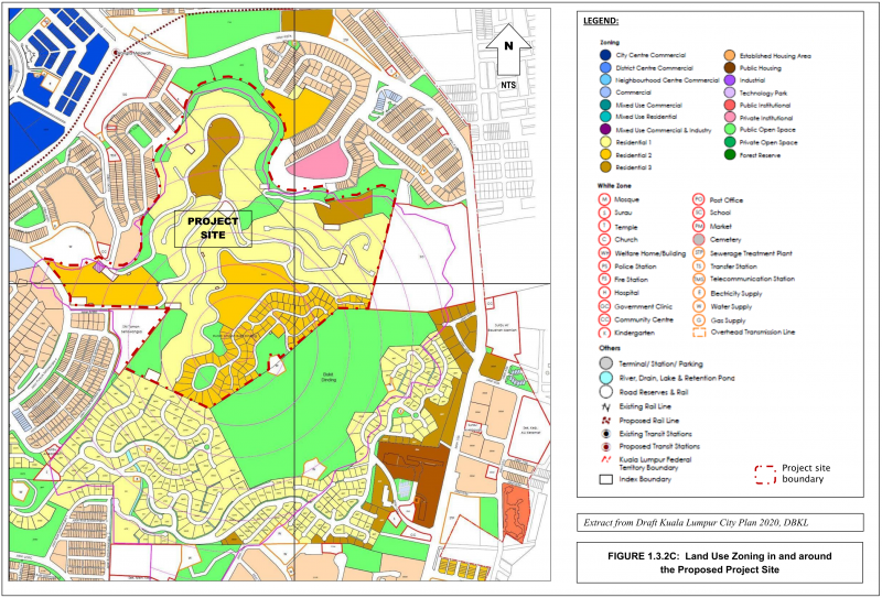
“FIGURE 1.3.2C: Land Use Zoning in and around the Proposed Project Site. Extract from Draft Kuala Lumpur City Plan 2020, DBKL” (ERINCO Sdn Bhd @ Enviro Knowledge Management Center (EKMC), Jabatan Alam Sekitar, Julai 2017: |"EIA for the Proposed Residential and Commercial Development On Lot 26413 Mukim Setapak and Lot 3538 Mukim Ulu Kelang, Kuala Lumpur For Nova Pesona Sdn Bhd").
2018-10-30: Pewartaan KLCP 2020
KLCP 2020 akhirnya diwartakan pada 30 Oktober 2018, namun banyak kandungannya telah dipinda dari versi asal yang turut melibatkan konflik kepentingan, serta tidak melalui proses pameran dan bantahan seperti sebelumnya: “30 Oct 2018: The new Mayor, with the approval of the new FT Minister, adopted and gazetted a version of the KLCP which was materially different to the version that had undergone public objection. The FT Minister also adopted and passed the KLCP when he was at the material time the Chairman of Yayasan Wilayah Persekutuan. YWP was also the owner and joint venture partner in relation to eleven pieces of land in the KLCP, many of which had zonings and development intensity which were inconsistent with the draft KLCP. Some of these lands had development orders already issued while some had not. The effect of the KLCP changes substantially enhanced the financial value of these YWP lands. 12 Nov 2018: The KLCP was made available to the public for reference. The contents of the KLCP: 1. were never presented to the public, in breach of the FTPA 2. are materially different to the Draft KLCP version 2008, which had gone through the public comments/objections process under FTPA 3. do not conform with the KL Structure Plan (gazetted 2004). The KLCP includes an Addendum 1 which lists 273 development orders(the “DOs”) and other changes that were never displayed for public objection and/or hearing.” (The Center to Combat Corruption and Cronyism (C4), 22 Jun 2020: "Kuala Lumpur City Plan (KLCP) 2020").
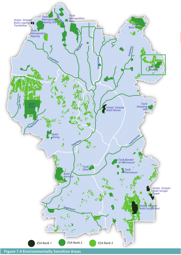
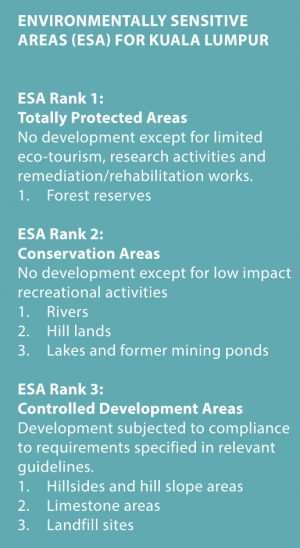
Environmentally Sensitive Areas (ESA).
“Strategic Direction 7.1: Protecting Environmentally Sensitive Areas. Hills, forest reserves and rivers are valuable natural resources that must be protected and conserved for the sustainability of Kuala Lumpur.
The Environmentally Sensitive Areas (ESAs) refer to areas that are highly sensitive to development or changes in land use and need to be conserved for its limited biodiversity value, to be maintained and enhanced for its life support and recreational functions and/or to be protected to mitigate the hazard risks to the surrounding areas. Identification, protection and control of developments on ESAs are generally defined by the NPP2 and subsequently, the ESAs are to be refined to suit local situation and requirements. Based on the NPP2 ESA categories and criteria, forest reserves and areas located on contour of 150 metres and above are to be designated as ESA category 2 and 3 respectively.
…
Additionally, risk areas have also been categorized as ESA. These include slope and hillsides, limestones and landfill sites. For Kuala Lumpur, protection and conservation of the ESAs are deemed important ot meet the following objectives:
i. Protection of limited natural assets such as forest and wildlife reserves to provide more green areas to support urban biodiversity as well as green lungs for the city;
ii. Protection against insensitive urban development;
iii. Protection from hazard risks such as erosion and land slides that could result in loss of life and properties;
iv. Protection against flood risk and improper drainage; and
v. Protection of the natural landscape to fulfill the recreational needs of its urban dwellers.”
“Key Initiative 7.1b - Protecting Hill Lands and Hillsides. Protecting of the hill lands and hillsides of Kuala Lumpur that form part of the natural urban landscape of the City for preservation against geo-hazards and fulfilling recreational needs of urban dwellers. The hill lands and hillsides of Kuala Lumpur are under tremendous pressure for development. The City has recognised that these areas form significant natural feature worthy of protection. At the same time, the City acknowledges that large part of these areas are privately owned and that their development is inevitable. Any form of development within these areas shall need to be undertaken in the most sensitive manner, this being:
i. Minimise disturbance of terrain;
ii. Incorporate existing natural features and vegetation into site design; and
iii. Ensure protection and safety of neighbouring and surrounding development.
Hill lands and hillsides within Kuala Lumpur are areas identified to include:
i. Significant hills which will be protected; and
ii. Areas with slopes under Class III and IV, (figure 7.9).
Developments within these areas shall need to comply to all the technical requirements under the relevant guidelines by KLCH and other agencies. (Garis Panduan Pembangunan Di Kawasan Bukit Dan Cerun Bagi Wilayah Persekutuan Kuala Lumpur, 2010).”
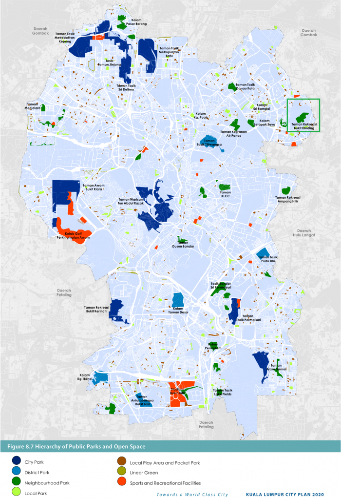
Sebagaimana yang telah dicadangkan di dalam Draf KLCP2020 pada tahun 2008, sebahagian besar kawasan Bukit Dinding diwartakan sebagai kediaman (Residential). Namun selebihnya dilabelkan sebagai “Taman Rekreasi Bukit Dinding” di dalam peta “Hierarchy Public Parks and Open Space” serta “Zoning”, dan keluasannya berkurang dari 70 ekar (dalam Deraf KLCP 2020) kepada 50 ekar (Warta KLCP 2020):-
Sumber: Perancangan Bandar Kuala Lumpur 2020, Jilid 1 (Kuala Lumpur City Hall, Oktober 2018: |"Kuala Lumpur City Plan (2020) Volume 1", m.s. 105-113, 129-131).
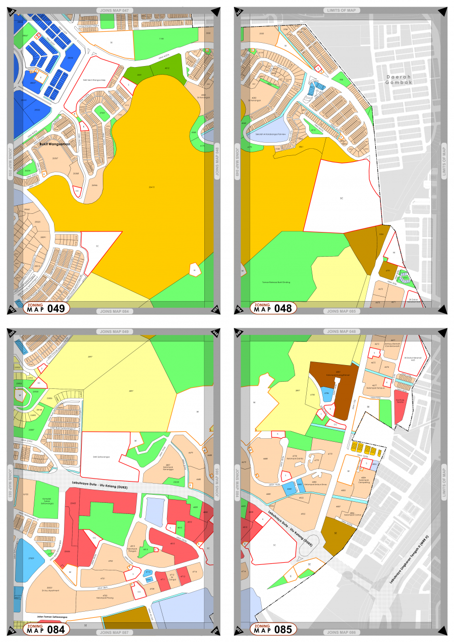
KLCP2020 Zoning Map: Bukit Dinding Area (Kuala Lumpur City Hall, Oktober 2018: |"Kuala Lumpur City Plan (2020) Volume 2", m.s. 204, 206, 276, 278).
2020-02-18: Draf Pelan Struktur Kuala Lumpur 2040 (PSKL 2040)
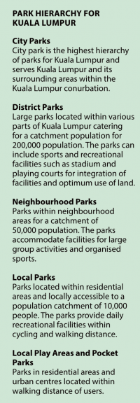
Di dalam Draf Pelan Struktur Kuala Lumpur 2040, persempadanan Bukit Dinding masih tidak berubah, dan status tanah kosong yang tinggal, dinyatakan sebagai “Taman Kejiranan” (“Neighborhood Park”). Sehingga kini, ianya kekal sebagai “tanah kosong”, dengan hanya pemancar Telekom Malaysia di puncaknya: “PSKL 2040 adalah kesinambungan dari PSKL 2020 yang perlu disemak kerana perubahan pembangunan dan ekonomi yang pesat. Wawasan dan dasar PSKL 2040 menggariskan misi bagi memacu pembangunan Kuala Lumpur bagi 20 tahun akan datang. Pembangunan di masa hadapan akan menumpukan kepada kesejahteraan warga kota, kualiti hidup, kesaksamaan, kemampanan serta ekonomi yang berdaya saing. Wargakota dan pihak yang berkepentingan adalah dijemput untuk menyertai dalam penyediaan deraf pelan ini.” (Dewan Bandaraya Kuala Lumpur, 18 Februari 2020: |"Majlis Pelancaran Draf Pelan Struktur Kuala Lumpur 2040 (PSKL 2040)").
“Government authorities had approved development of high-rise condominiums and a new township on Bukit Dinding, despite its Environmental Protection Zone (EPZ) status in Kuala Lumpur City Plan 2020. Bukit Dinding is a significant miss-out from the Urban Forest category. Tagged as 'Taman Rekreasi Bukit Dinding' through draft stages of KLCP2020, it is now reduced from 70 acres (KLSP2020 depiction) to 50 acres (KLCP2020 & draft KLSP2040 depiction). Meanwhile reality on the ground is that DBKL has yet to create a public park there throughout the 2000–2020 period – it remains to this day as 'vacant land', with Telekom Malaysia being the only institutional presence on the hill. Despite this lack of attention by DBKL, it has attracted a community of regular users, which grew significantly during the COVID-19 RMCO period.” (Wikipedia: Bukit Dinding: "Kuala Lumpur City Plan 2020").
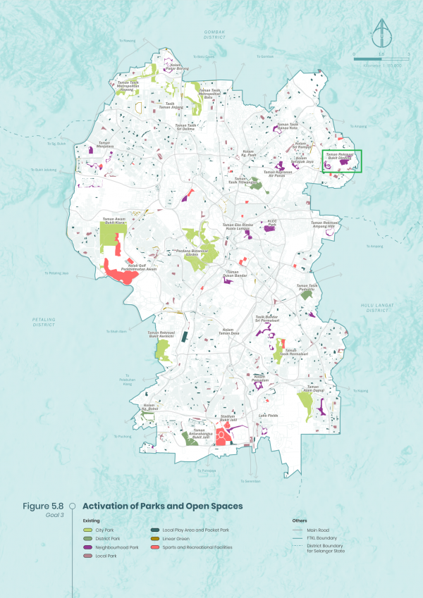
Sebahagian Bukit Dinding ditandakan sebagai “Neighbourhood Park” (Dewan Bandaraya Kuala Lumpur, 2020: |"Kuala Lumpur City Plan (2040) Draft", m.s.116).
2022-03-28: Kelulusan Pembangunan 2 Blok Pangsapuri
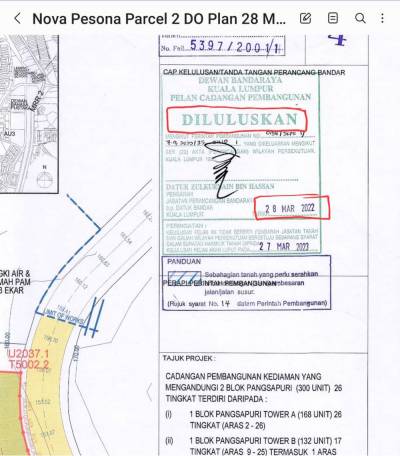
Pada 28 Mac 2022, Pengarah Jabatan Kemajuan Bandar Zulkurnain Hassan telah meluluskan cadangan pembangunan 2 blok pangsapuri oleh syarikat Nova Pesona Sdn Bhd, sebagai kesinambungan kepada perancangan bandar sedia ada, dan disokong oleh laporan Penilaian Kesan Alam Sekitar (Environment Impact Assessment - EIA) pada tahun 2017 dahulu. Penduduk setempat yang tidak dimaklumkan mengenai hal-hal ini telah membuat bantahan berdasarkan EIA yang terlalu lama dan tidak menyeluruh, iaitu tidak membuat kajian cerun serta tidak mengambil kira risiko-risiko tanah runtuh dan lain-lain: “Kelulusan Dewan Bandaraya Kuala Lumpur (DBKL) baru-baru ini untuk pembangunan dua blok kondominium melibatkan 300 unit kediaman di Bukit Dinding yang diisytiharkan sebagai kawasan “berisiko tinggi” tanah runtuh pada 2014 mendapat bantahan keras daripada sekurang-kurangnya 6,000 penduduk sekitar. … Menurut kelulusan perancangan yang dilihat oleh Malaysiakini (lihat pelan yang diluluskan) cadangan pelan pembangunan untuk 300 unit kondominium itu telah dikemukakan pada 27 Sept tahun lepas dan diluluskan oleh Pengarah Jabatan Kemajuan Bandar Zulkurnain Hassan pada 28 Mac tahun ini. Bagaimanapun, Zaliny berkata pemaju mengalah kepada mesyuarat pada 15 Sept hanya selepas penduduk mula menulis ke DBKL. “Kami bukan sahaja tidak tahu mengenai kelulusan itu, malah Nova Pesona juga enggan berkongsi sebarang rancangan lain selain dari kawasan kecil yang dihasratkan mereka untuk memulakan pembangunan. “Perancangan untuk seluruh bukit itu, kami dapati hanya apabila kami mendapatkan laporan EIA sendiri. “Kami telah mendaftarkan bantahan secara terang-terangan kerana laporan EIA sudah lapuk dan insiden tanah runtuh yang lebih baru di Bukit Dinding mungkin tidak diambil kira,” tegasnya.”
(Sumber: S Vinothaa @ Malaysiakini, 25-28 September, 2022: |"Penduduk bantah kelulusan pembangunan DBKL di bukit 'berisiko runtuh'").
2022 (15 September-kini): Bantahan Penduduk Sekitar
Pada 15 September 2022, suatu sesi perjumpaan telah diadakan di antara syarikat pemaju Nova Pesona Sdn Bhd dan penduduk setempat. Di dalam sesi tersebut, pihak penduduk telah menyuarakan bantahan mereka terhadap pembinaan 2 blok kondominium 26 tingkat di situ, atas dasar kekhuatiran terhadap kesan-kesannya seperti tanah runtuh, banjir, dan kesesakan lalulintas. Pihak penduduk berpendapat, pihak syarikat telah gagal meyakinkan mereka berkenaan isu-isu tersebut, lalu bertindak meneruskan bantahan mereka melalui saluran-saluran media serta ruang awam. Pada 26 September, Datuk Bandar Kuala Lumpur menyatakan 25% daripada kawasan itu harus dikekalkan sebagai kawasan hijau, dan kerja pembinaan tidak boleh dimulakan selagi siri perbincangan dengan penduduk setempat belum dijalankan. Pada Oktober 18, penduduk setempat telah membuat laporan polis terhadap pihak pemaju, atas dakwaan penggunaan laporan EIA yang telah tamat tempohnya (2017, iaitu lebih daripada 2 tahun). Pihak pemaju pula menyatakan kawasan tersebut telah pun diwartakan sebagai kawasan kediaman sejak 1983 lagi, dan perkara ini turut termaktub di dalam Kuala Lumpur City Plan 2020. Menurutnya lagi, sistem perparitan akan dibina mengikut panduan keselamatan JKR, lalu akan dapat membendung larian air yang merupakan kekhuatiran utama penduduk setempat.
“On 15 September 2022, a meeting Sesi Komunikasi Strategi Sebelum Pembinaan was called by the developer Nova Pesona Sdn Bhd, attended by 125 persons mostly residents of homes around Bukit Dinding. The developer revealed that DBKL had issued them the Development order dated 28 March 2022, with timelines of earthworks to commence at Q4 2022. The residents had openly opposed to the development stating various concerns, mostly on risks of landslide, flood and traffic concerns. On 22 September 2022, DBKL has warned developer Nova Pesona against starting work on Bukit Dinding despite of their Development Order, until discussion with residents finalised. DBKL reiterated that no work should be carried out until residents were fully-informed about the development, which had seen huge opposition from residents in the area over safety concerns. Between 15 and 17 October 2022, four resident associations have lodged police report against the Developer Nova Pesona Sdn Bhd. feeling threatened by the purported development.”
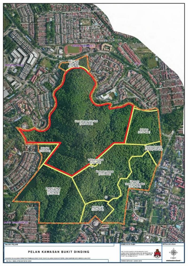
Pelan Kawasan Bukit Dinding (Jabatan Perancangan Bandaraya, Dewan Bandaraya Kuala Lumpur, 22 Mac 2019 @ FB Friends of Bukit Dinding, 8 Oktober 2022: "Satu-satunya yang indah dalam peta ini adalah Bukit Dinding").
Syarikat Nova Pesona memiliki bahagian terbesar Bukit Dinding (seluas 130 ekar), sebagaimana ditandakan dengan sempadan merah di dalam peta di atas. Semua hal-hal di atas ini tidak dimaklumkan kepada penduduk setempat. Mereka hanya mendapat tahu mengenainya 5 tahun selepasnya, berikutan bantahan kelulusan pembangunan 2 blok pangsapuri di situ:-
“A map titled “Pelan Kawasan Bukit Dinding” by Jabatan Perancangan Bandaraya DBKL went viral on the internet in 2022. It suddenly came to public knowledge that almost all the land areas on the hill are owned by five respective developers, a total of over 225 acres. In reality, these land parcels have always been zoned as residential since 1983. The general public had mistakenly assumed that the development projects would not proceed considering landslides incidents at nearby Highland Tower and Bukit Antarabangsa.
…
Developer: Nova Pesona Sdn Bhd
Direction: North West Bukit Dinding
Land Area: 130 acres
To be Affected Residents: Seksyen 5 Wangsa Maju, Fairview International School, Sri Kenangan Condominium and surrounding
Status: DBKL Development Order (D.O.) has been obtained on 28 March 2022 - facing strong protests from residents and other stakeholders.”
(Sumber: Wikipedia: Bukit Dinding: "List of Developers / Land Owners of Plots on Bukit Dinding").
Liputan akhbar mengenai bantahan-bantahan penduduk setempat: “Tension is brewing among residents near Bukit Dinding in Kuala Lumpur as they are unhappy with the developer’s and the authorities’ response to concerns about a proposed development at the hill. The lush landscape, popular as a recreational venue among locals, is located on the border between Setiawangsa and Wangsa Maju in Kuala Lumpur. After news broke out last month that two blocks of 26-storey condominiums will be built there, residents in the area set up social media accounts and put up banners opposing the project. Lodging Heights 1 condominium resident Fatimah Nagoor, 65, said the development would bring more traffic into the area and the road would not be able to cope with the increase in volume. “We were informed that the developer will use the narrow Jalan 1/27c during construction, which will inconvenience residents. “There are many housing areas here and heavy vehicles plying our neighbourhood roads will affect us badly,” she said. Wazuri 1 Residents Association chairman Syahrom Jumali, 42, said Bukit Dinding was not strong enough to support the proposed buildings. He expressed concern that his condominium, located behind the hill, would be at risk if the development went ahead. “There is a stream at the hill, which could weaken the soil structure. We often see landslips after downpours. “We are worried that if this project is allowed, more developments will take place here in future,” Syahrom added. On Sept 26, Kuala Lumpur mayor Datuk Seri Mahadi Che Ngah said 25% of the site must be maintained as a green area. He also stressed that no works should take place until engagement sessions with residents were finalised, although no deadline had been given. On Oct 18, residents lodged a police report against the developer for allegedly misleading them about the project. They claimed that the developer used an outdated environmental impact assessment (EIA) report from 2017, which was only valid for two years. Fatimah said a meeting with the developer on Sept 15 failed to dispel residents’ fears about the project. “Many things were poorly explained and the residents were left with more questions instead,” she added. Syahrom said Kuala Lumpur City Hall (DBKL) should take charge and moderate these engagement sessions to ensure transparency. Meanwhile, a group of fitness enthusiasts called “NRG”, consisting of some 60 members, have been exercising regularly at Bukit Dinding. Suparman Samsuddin, 38, who heads the group, said they would meet every Wednesday to hike up the hill and enjoy the scenery. “The site is the perfect ground to train for long-distance running. On weekends, many families also come to enjoy the greenery. “This hill is one the few green lungs left and must be preserved. Further developments will disrupt the ecosystem of the hill,” he said. The developer Nova Pesona Sdn Bhd, in response, said its land had been designated for residential use since 1983. In a statement to StarMetro, the company said the development was also gazetted under the then Kuala Lumpur City Plan 2020. “The 52.5ha parcel is only part of Bukit Dinding and does not constitute the entire hill. There are other lots with different owners,” it said. On concerns over the soil integrity, Nova Pesona said it was normal for groundwater to exist in natural slopes. It said drains were installed to capture and release stormwater, adding it would comply with the guidelines from the Public Works Department to ensure safety.” (Farid Wahab @ The Star, 05 Nov 2022: |"Concerns grow over Bukit Dinding hill project").
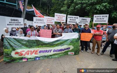
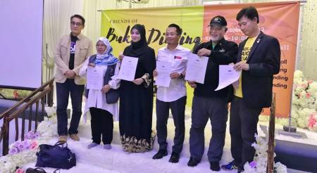
Kiri: “Ahli Parlimen Wangsa Maju Nik Nazmi Nik Ahmad membuat tinjauan bersama wakil penduduk mengenai bantahan projek di Bukit Dinding pada petang ini.” (Anne Muhammad @ Free Malaysia Today, September 26, 2022: |"Pembangunan Bukit Dinding: Nik Nazmi desak pertemuan antara DBKL dan penduduk").
Kanan: Pada 16 November 2022, di dalam suatu perjumpaan anjuran “Friends of Bukit Dinding”, 5 daripada 6 orang calon pilihanraya yang bertanding bagi kerusi parlimen P118 Setiawangsa turut hadir, termasuk penyandang ahli parlimen Nik Nazmi Nik Ahmad (Pakatan Harapan), Nurul Fadzilah Kamaluddin (Perikatan Nasional) dan Bibi Sunita Sakandar Khan (Pejuang). Mereka telah menandatangani akujanji untuk mempertahankan Bukit Dinding: “During the FoBD Townhall, 5 Candidates of P118 Setiawangsa pledged against the development of Bukit Dinding On 16 November 2022, during the Townhall event by Friends of Bukit Dinding, five out six candidates showed up, which included incumbent MP Nik Nazmi Nik Ahmad (Pakatan Harapan), Nurul Fadzilah Kamaluddin (Perikatan Nasional) and Bibi Sunita Sakandar Khan (Pejuang) have signed the pledge to protect Bukit Dinding.” (Wikipedia).
Bukit Dinding Kini
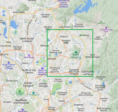
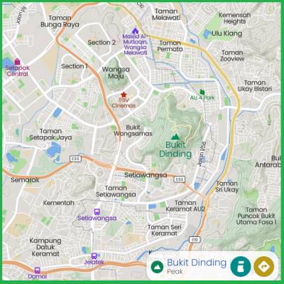
Peta sekitar Bukit Dinding, kini (Mapcarta).
Kini, Bukit Dinding terus diancam pembangunan, sebagaimana yang telah dirancang sejak beberapa dekad yang lampau. Senarai penuh pemaju / pemilik plot-plot tanah Bukit Dinding:-
“List of developers / land owners of plots on Bukit Dinding:-
1. Developer: Kerjaya Prospek Property Sdn Bhd
Direction: East of Bukit Dinding
Affected Residents: Kelumpuk Serindit, Keramat AU and surrounding
Status: Kaleidoscope Condominium - completed in year 2020
Description: In year 2014, the affected residents had actively protested and objected against the development - but to no avail.
Aftermath: Ongoing flooding from rain and bad drainage system. Flood water damaged homes and cars. Wild animals from the hill (especially snakes) escaping into lower homes in affected areas.
2. Developer: Nova Pesona Sdn Bhd
Direction: North West Bukit Dinding
Land Area: 130 acres
To be Affected Residents: Seksyen 5 Wangsa Maju, Fairview International School, Sri Kenangan Condominium and surrounding
Status: DBKL Development Order (D.O.) has been obtained on 28 March 2022 - facing strong protests from residents and other stakeholders.
3. Developer: Harmony Properties Sdn Bhd
Direction: East of Bukit Dinding
Land Area: 33 acres
To be Affected Residents: vs Kelumpuk Kenari A, Kelumpuk Kuang C, part of Keramat AU towards Hulu Kelang
Status: Unknown
4. Developer: Paragrene Land Berhad
Direction: South Bukit Dinding
Land Area: 56 acres
To be Affected Residents: Bukit Wangsamas, Taman Setiawangsa and surrounding
Status: Unknown
5. Developer: MCL Properties Sdn Bhd
Direction: North West Bukit Dinding
Land Area: 5 acres
To be Affected Residents: Bukit Wangsamas, Taman Setiawangsa and surrounding
Status: Paragrene Land Berhad had purchased the land in February 2021 for RM 10 Million. The land then revalued for RM35 Million.”
(Sumber: Wikipedia: Bukit Dinding: "List of Developers / Land Owners of Plots on Bukit Dinding").
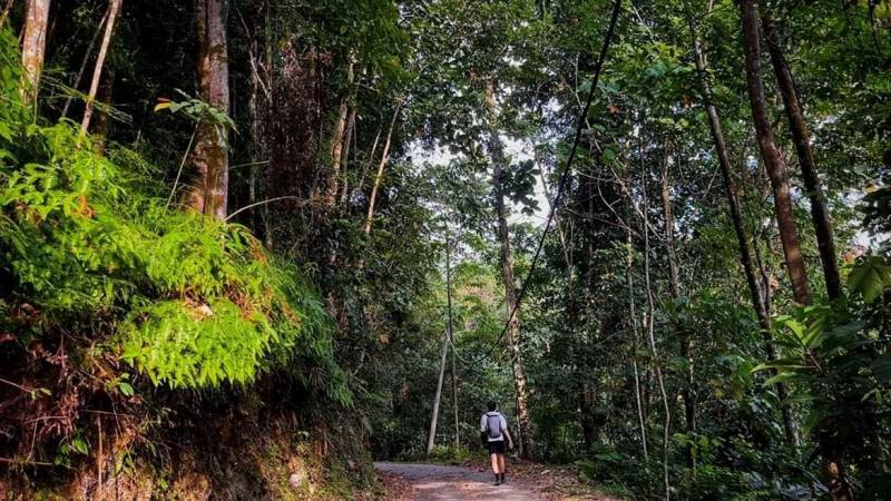
Hutan Bukit Dinding (Lance Tang @ Facebook, 26 Oktober 2022: "Friends of Bukit Dinding").
| Laman Utama | Hubungi Kami | ||||||||
| Siri Cebisan Sejarah: | Bangi | Gambang | Hutan | Ipoh | Kajang | Kuala Lumpur | Kuantan | Pulau Pinang | Hubungi Kami |

